
Great Civil War map of Yorktown & Norfolk & vicinity...
Item # 709938
·
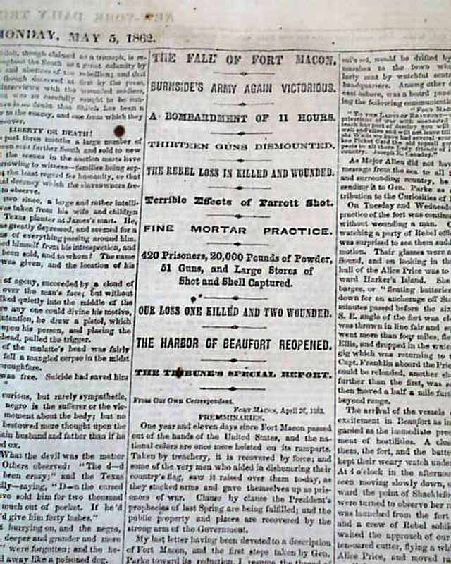
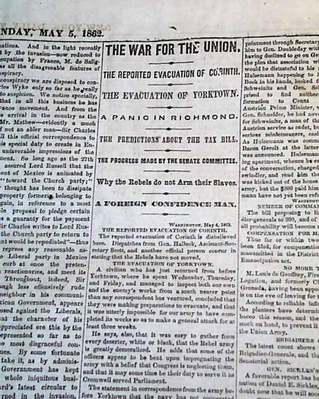
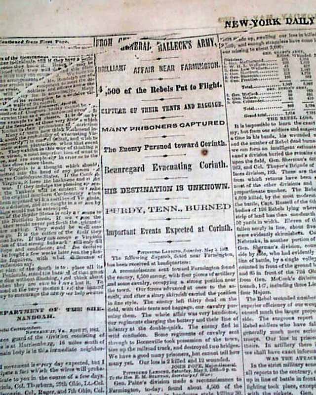
NEW YORK TRIBUNE, May 5, 1862
* George B. McClellan's Peninsula Campaign map
* Siege & capture of Yorktown & Gloucester Point
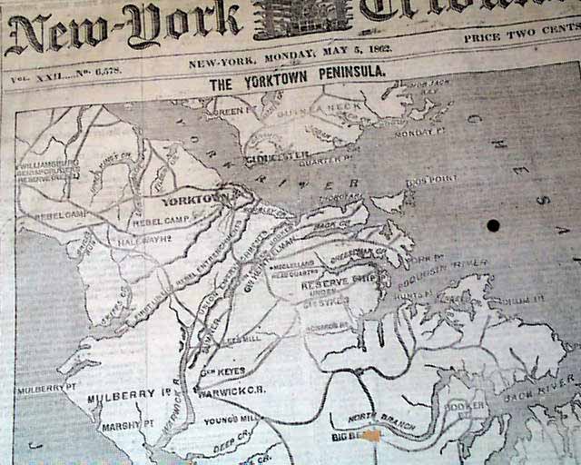
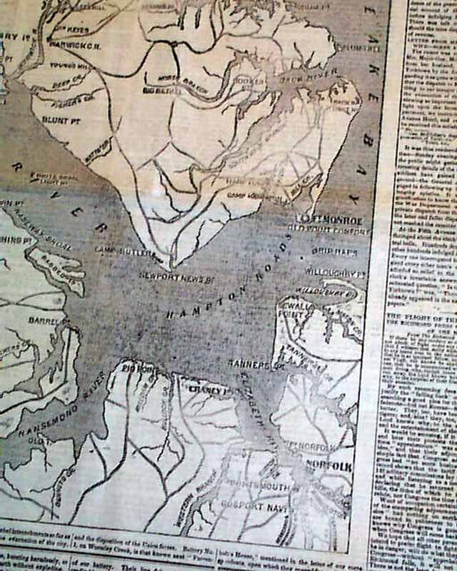
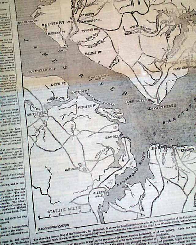
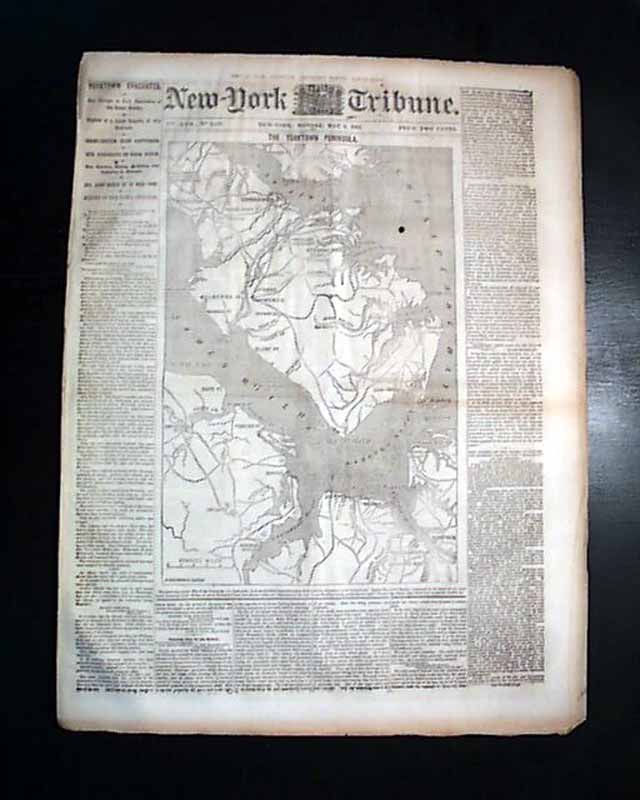
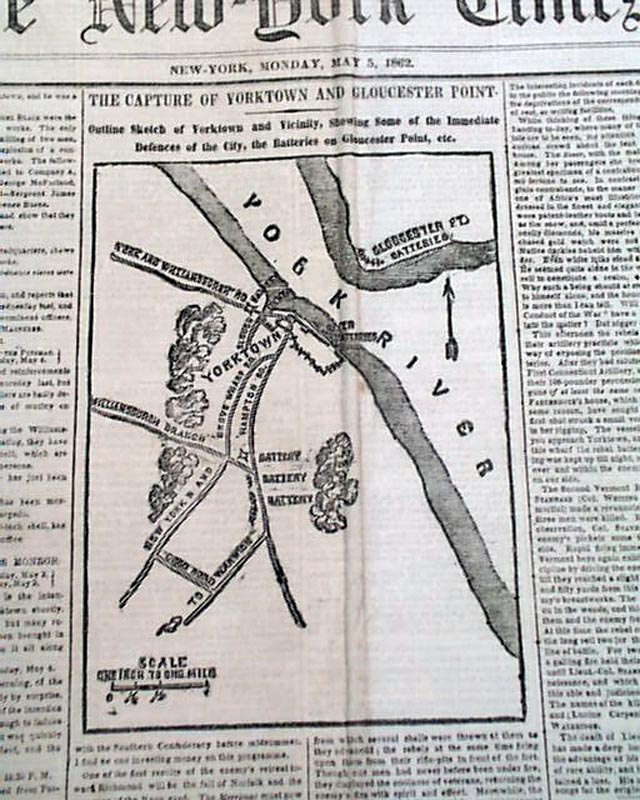
The front page is dominated by a huge Civil War map headed: "THE YORKTOWN PENINSULA" which shows from Yorktown to Norfolk and much in between.
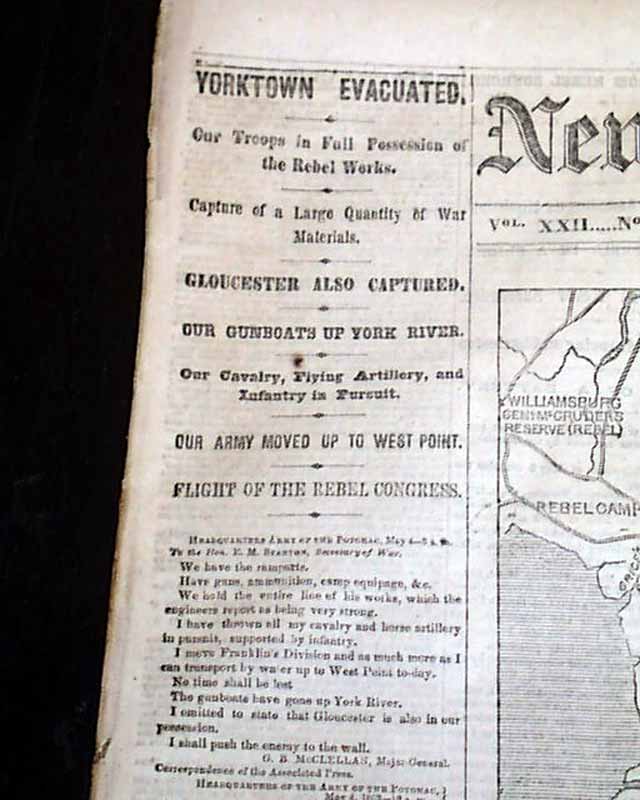
Nice first column heads as well including: "YORKTOWN EVACUATED" "Our Troops in Full Possession of the Rebel Works" "Gloucester Also Captured & more.
Twelve pages, never bound nor trimmed, very nice condition.
Background: This museum-quality issue of the New York Tribune from May 5, 1862, offers a breathtaking visual time capsule of the American Civil War, dominated by a massive, sprawling front-page woodcut map of "The Yorktown Peninsula." The cartography is remarkably crisp, tracing the high-stakes theater from Yorktown to Norfolk with the intricate detail of a campaign strategist’s notebook. Bold, "breaking news" headlines leap off the page in a tall, authoritative stack, triumphantly announcing "YORKTOWN EVACUATED" and "Our Troops in Full Possession," capturing the raw electricity of the Union’s breakthrough just as it hit the streets of New York. Because this rare twelve-page specimen remains never bound nor trimmed, it retains its original, expansive folio dimensions and clean edges, free from the heavy cropping or spine-damage typical of library archives. Printed on durable rag paper that has defied the centuries, this is not just a newspaper—it is a stunning, high-contrast display piece that puts the pivotal Siege of Yorktown directly into your hands.
* George B. McClellan's Peninsula Campaign map
* Siege & capture of Yorktown & Gloucester Point
The front page is dominated by a huge Civil War map headed: "THE YORKTOWN PENINSULA" which shows from Yorktown to Norfolk and much in between.
Nice first column heads as well including: "YORKTOWN EVACUATED" "Our Troops in Full Possession of the Rebel Works" "Gloucester Also Captured & more.
Twelve pages, never bound nor trimmed, very nice condition.
Background: This museum-quality issue of the New York Tribune from May 5, 1862, offers a breathtaking visual time capsule of the American Civil War, dominated by a massive, sprawling front-page woodcut map of "The Yorktown Peninsula." The cartography is remarkably crisp, tracing the high-stakes theater from Yorktown to Norfolk with the intricate detail of a campaign strategist’s notebook. Bold, "breaking news" headlines leap off the page in a tall, authoritative stack, triumphantly announcing "YORKTOWN EVACUATED" and "Our Troops in Full Possession," capturing the raw electricity of the Union’s breakthrough just as it hit the streets of New York. Because this rare twelve-page specimen remains never bound nor trimmed, it retains its original, expansive folio dimensions and clean edges, free from the heavy cropping or spine-damage typical of library archives. Printed on durable rag paper that has defied the centuries, this is not just a newspaper—it is a stunning, high-contrast display piece that puts the pivotal Siege of Yorktown directly into your hands.
Category: Yankee
Price
$55
100% Authentic: Original printing, never a reproduction.
Other issues you may like
§ related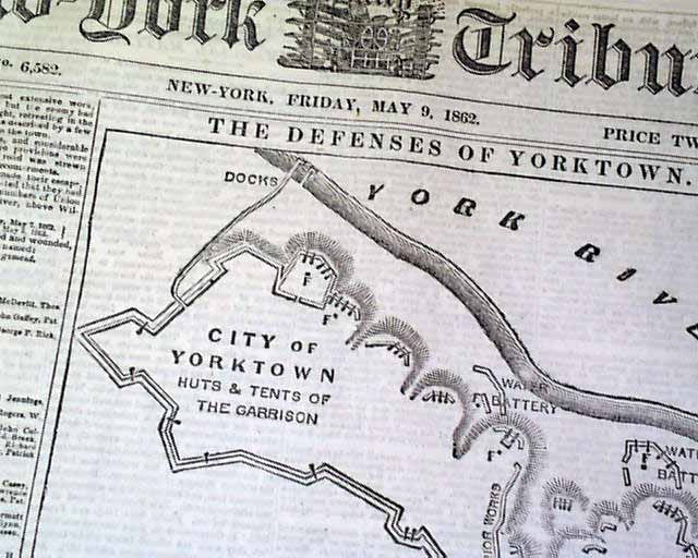
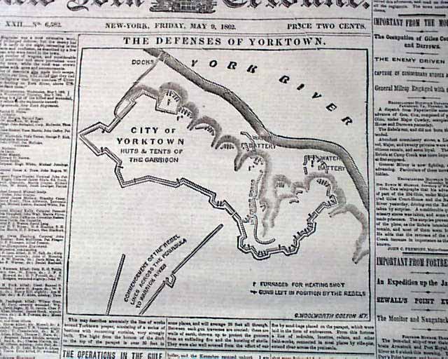
Civil War map of the Yorktown vicinity...
NEW YORK TRIBUNE, May 9, 1862
* Siege of Yorktown ends
* Battle of Williamsburg, Virginia
* New Orleans LA Louisiana
The front page is dominated...
* Siege of Yorktown ends
* Battle of Williamsburg, Virginia
* New Orleans LA Louisiana
The front page is dominated...
May 1862
$50
Civil War map of the Yorktown vicinity...
NEW YORK TRIBUNE, May 9, 1862
* Siege of Yorktown ends
* Battle of Williamsburg, Virginia
* New Orleans LA Louisiana
The front page is dominated by...
* Siege of Yorktown ends
* Battle of Williamsburg, Virginia
* New Orleans LA Louisiana
The front page is dominated by...
May 1862
$52
Yorktown, VA map...
THE NEW YORK TIMES, New York, May 5, 1862
* Battle or Siege of Yorktown, Virginia
* General George B. McClellan
This Genuine newspaper has a Wealth...
* Battle or Siege of Yorktown, Virginia
* General George B. McClellan
This Genuine newspaper has a Wealth...
May 1862
$57
Capture of Yorktown and Gloucester... Civil War map...
NEW YORK TIMES, May 5, 1862
* George b. McClellan's Peninsula Campaign
* Siege & capture of Yorktown & Gloucester Point
The front page is dominated by a...
* George b. McClellan's Peninsula Campaign
* Siege & capture of Yorktown & Gloucester Point
The front page is dominated by a...
May 1862
$50