
Other Potential Titles... |
|
Note: In addition to what may or may not be shown below, issues may be available for this date which have yet to be listed on our website. View Potential Titles for 01/01/1600 Due to the size of our inventory, it is possible we still may have what you are looking for. Please call (570-326-1045) or send your request to info@rarenewspapers.com. |
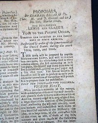
Much on Lewis & Clark & their exploration to the Pacific...
Item #715881
October 02, 1807
NATIONAL INTELLIGENCER, Washington, D.C., Oct. 2, 1807
* Lewis and Clark expedition
Page 3 has a very lengthy: "Proposals...For Publishing LEWIS and CLARK'S Tour to the Pacific Ocean, through the Interior of the Continent of North America..." noting the details that will be in "Volume First" as well as "Volume Second". And this is followed by another d... See More
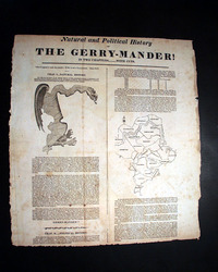
Rare piece of political Americana: the Gerry-Mander...
Item #715496
January 01, 1817
Terrific broadside: "Natural And Political History of THE GERRY-MANDER! In Two Chapters.....With Cuts."
* Extremely rare broadside
* Eldridge Gerry - Gerrymandering
* Essex County, Massachusetts redistricting
* Republicans & upcoming state elections
Information from dealer Barry Lawrence Ruderman notes:
"Rare political broadside featuring the first political cartoon i... See More
1873 Intercollegiate Regatta... rowing...
Item #714503
July 18, 1875
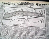
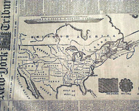
NEW YORK TRIBUNE, July 18, 1873
* Intercollegiate Regatta
* Connecticut River
* Springfield, Massachusetts
* Boat - rowing
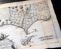
The top of the front page has a four column map headed: "The Regatta Course At Springfield" which shows area where the race was to be held with the college boarding places. (see images) One column headings include: "THE COLLEGE REGATTA" and more. ... See More
1873 Polaris expedition to North Pole..
Item #711968
September 11, 1873
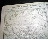
NEW YORK HERALD, Sept. 11, 1873
* Polaris expedition to North Pole (hardships)
The top of page 5 has a one column heading: "THE POLARIS" with many subheads. (see images) Lengthy text continues on page 6 with large map headed: "THE NORTH POLAR REGIONS; Map Showing the Explorations for an Open Polar Sea and the Scenes of the Search for the Polaris crew by the Tigress and Juniat... See More
Three great plates on the Seven Years' War...
Item #709995
THE GENTLEMAN'S MAGAZINE, London, August, 1759 Of prime interest are the 3 full page plates on the Seven Years' War, the first titled: "A Map of the Part of Westphalia in which the French Army Were Defeated , Aug. 1, 1759" which shows much details (see), the plate titled: "Line of Battle of the Allied Army Before the Engagement on the First of August, 1759", plus ... See More
Two European maps...
Item #709987
GENTLEMAN'S MAGAZINE, London, July, 1758 The prime features of this issue are the two maps, one being a full page plate titled: "A Map of the Rhine Between Wesel & Duseldorp..." (see), and the other a foldout map measuring 8 by 10 1/2 inches titled "A Complete Chart of the Coast of France from Ostend, to Cape Finisterra, including the Opposite Coast of the British Chan... See More
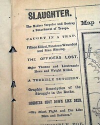
Battle of Sand Butte... 1873 Modoc War...
Item #707250
April 30, 1873
NEW YORK HERALD, April 30, 1873
* Battle of Sand Butte
* Modocs Indians War
* U.S. soldiers massacre
* Captain Evan Thomas killed
* Scarface Charley victory
Page 5 has a terrific report on the Battle of Sand Butte during the Modoc War. The top of the page has a one column heading: "SLAUGHTER" with several subheads and related map. (see images) Text takes up the entire page and ... See More
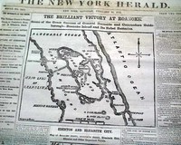
Two front page Civil War maps...
Item #706402
February 15, 1862
NEW YORK HERALD, Feb. 15, 1862
* Roanoke Island North Carolina
* Edenton & Elizabeth City NC
The front page is dominated by two nice Civil War maps, headed: "THE BRILLIANT VICTORY AT ROANOKE" and: "EDENTON AND ELIZABETH CITY".
First column heads report much on the war including events relating to the two maps. Some include: "The Integrity of the Union&qu... See More
Map of Charleston, South Carolina...
Item #705321
January 05, 1862
NEW YORK HERALD, Jan. 5, 1862 The front page features a large Civil War map headed: "IMPORTANT MOVEMENTS NEAR CHARLESTON, S. C." Among the one column headlines on the Civil War are: "IMPORTANT FROM THE SOUTH" "Operations on the Charleston and Savannah Railroad" "Seizure of the Station Near Charleston: "Desperate Battle and Defeat of the Rebels Near Por... See More
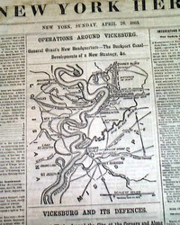
Two maps of operations around Vicksburg...
Item #705319
April 26, 1863
NEW YORK HERALD, April 26, 1863 The front page features two maps headed: "OPERATIONS AROUND VICKSBURG" and: "VICKSBURG AND IT'S DEFENSES" with much detail.
Among the front page one column headlines on the Civil War are: "NEWS FROM THE SOUTHWEST" "The Fight On The Coldwater River" "The Position and Strategy of General Grant" "NEWS FR... See More
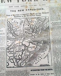
Civil War map of the Savannah vicinity...
Item #705318
January 31, 1862
NEW YORK HERALD, Jan. 31, 1862 The front page features a nice map headed: "THE NEW EXPEDITION. Scene of Operations of Commodore Dupont & Gen. Sherman's Expedition to the Rear of Fort Pulaski".
Also on the front page is a wealth of war heads including: "Important From Savannah" "Splendid Naval Movement" "Interesting From the South" "The Fr... See More
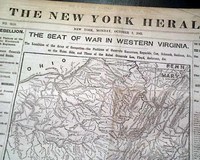
Large Civil War map on the front page...
Item #705314
October 07, 1861
NEW YORK HERALD, Oct. 7, 1861 The front page is dominated by a very large & very detailed Civil War map headed: "THE SEAT OF WAR IN WESTERN VIRGINIA". Plus many front page column heads on the war: "THE REBELLION" "Interview Between Generals McClellan & Banks" "Important News from the Cherokee Nation" "The Scene of War in Western Virginia&q... See More
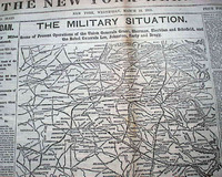
Large & displayable Civil War map...
Item #705313
March 15, 1865
NEW YORK HERALD, March 15, 1865 The front page features a huge & extremely detailed Civil War map headed: "THE MILITARY SITUATION. Scene of Present Operations of the Union Generals Grant, Sherman, Sheridan, and Schofield & the Rebels Generals Lee, Johnston, Early and Bragg." The map shows from Lynchburg to Wilmington, N. Carolina; to Columbia, Georgia; to Petersburg, Va.
A... See More
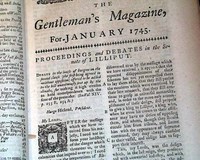
Finding a Northwest Passage... Protecting the Carolinas...
Item #705256
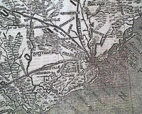
THE GENTLEMAN'S MAGAZINE, London, January, 1745 Over 1 1/2 pages are taken up with: "The case of Carolina Consider'd, with Regard to its Danger of being Invaded, for want of Regular Forces...". This is a great article on the defense of the colonies. Three-quarters of a page are taken up with: "A List of Privateers".Among other articles are: "Speech on the R... See More
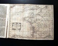
Map of Germany... The Mississippi River...
Item #705250
THE GENTLEMAN'S MAGAZINE, London, January, 1761 An article: "Thoughts on the Present Posture of Affairs" includes some discussion concerning America, and includes: "...Hence it is evident that as North America was the bone of contention, Great Britain must not be induced to part with any of her conquests on that continent; because that would be a means to renew the war...&... See More
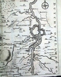
Map of Maastricht, The Netherlands... Battle of Val Lauffeld)...
Item #705041
THE GENTLEMAN'S MAGAZINE, London, July, 1747 (with map)* Battle of Lauffeld (also Maastricht, or Val)
* Map of Maastricht, The Netherlands
* Coal mine fires
A nice feature is a foldout map titled: "A Plan of Maestricht, with the Adjacent Villages where the Battle was fought June 21...", which is in The Netherlands. The map shows considerable details - folding out to measure ... See More
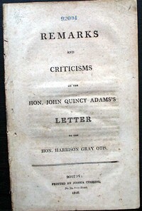
1808 pamphlet - John Quincy Adams & Harrison Grey Otis...
Item #705028
January 01, 1839
Pamphlet: "REMARKS and CRITICISMS on the Hon. JOHN QUINCY ADAMS'S LETTER to the Hon. HARRISON GRAY OTIS", by William Coleman, a law partner of Aaron Burr, and printed by Joshua Cushing, Boston, 1808
Critique of John Quincy Adams' thoughts on the War of 1812 as presented to Harrison Gray Otis. Wordery comments: "It offers insight into the political debates of the time and ... See More
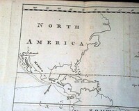
Great map of the western hemisphere...
Item #704974
THE GENTLEMAN'S MAGAZINE, London, December, 1773 Certainly the prime feature of this issue is the nice foldout map that accompanies the lengthy article: "Epitome of Lieut. Cooke's Voyage Round the World", showing most of North America, all of South America down to Cape Horn, and even portions of West Africa, Spain, France & England. Notice the shape of Florida & Cal... See More
John Wilkes Booth 3 years before his notoriety...
Item #704904
March 17, 1862
NEW YORK TRIBUNE, March 17, 1862
* John Wilkes Booth theater ad
* Civil War original reporting
The front page contains one of the fascinating tidbits of history which delight collectors, in this case an inconspicuous advertisement for a theatrical production of Richard III at the Mary Provost Theater in New York--starring John Wilkes Booth. See the photo below for the complete ... See More
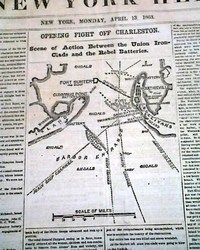
Map of Charleston Harbor...
Item #704753
April 13, 1863
NEW YORK HERALD, April 13, 1863
* First Battle of Charleston Harbor - South Carolina
The front page features a nice Civil War map headed: "OPENING FIGHT OFF CHARLESTON - Scene of Action Between the Union Iron-Clads & the Rebel Batteries".
Among the first column heads: "The Fight At Charleston" "The Keokuk Destroyed by a Torpedo" "Tremendous Fire of the... See More
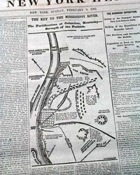
Map shows details of Columbus, Kentucky...
Item #704752
February 09, 1862
NEW YORK HERALD, Feb. 9, 1862
* Columbus, Kentucky Confederate fortifications map
The front page features a nice and detailed map headed: "The Key To The Mississippi River. The Fortifications at Columbus, Kentucky--Strength of the Position."
The balance of the front page is taken up with various Civil War reports with column heads including: "The Rebel Defences of Colum... See More
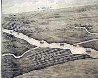
Short-lived title from Texas... Large map of the Brazos...
Item #704746
March 02, 1892
VELASCO DAILY TIMES, Texas, March 2, 1892
* Rare Southwestern publication
* Possibly the first time offered anywhere (see note)
A rare title as it existed for less than six months.
Velasco was a town in Texas that was later annexed by the city of Freeport. Founded in 1831, Velasco is situated on the east side of the Brazos River four miles from the Gulf of Mexico. The town'... See More
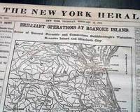
Two Civil War maps: front page and back page...
Item #704622
February 13, 1862
NEW YORK HERALD, Feb. 13, 1862
* Battle of Roanoke Island w/ map
* Ambrose Burnside & Louis M. Goldsborough
Taking close to half of the front page is a great map: "Brilliant Operations At Roanoke Island -- Scene of General Burnside and Commodore Goldsborough's Victories--Roanoke Island & Elizabeth City." The map and reports take all of the front page and conclud... See More
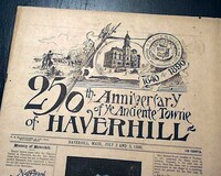
Focused on the history of Haverhill, Mass...
Item #704285
July 03, 1890
250TH ANNIVERSARY OF YE ANCIENTE TOWN OF HAVERHILL, Massachusetts, July 2 & 3, 1890 Yeah, this is not a bonafide newspaper, but rather a special publication devoted to the celebration of the 250 years of this historic town. And that was over 130 years ago!
The entire issue is focused on the early history of the town with serveral photos of the founding fathers, some maps, buildings, etc... See More
The Spanish-American War...
Item #704266
July 26, 1898
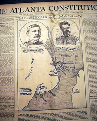
THE ATLANTA CONSTITUTION, Georgia, July 26, 1898 The front page is dominated by a map headed: "THE SIEGE OF MANILA" with insets of Brig. Gen,. Francis V. Greene, and Gen. Thos. M. Anderson.
Front page one column reads include: "Hurrying Troops On To Porto Rico" "No Trouble In Embarking" "Soldiers Gather at Newport News" "Not To Santiago But Porto... See More
Huge front page Tennessee Battle map...
Item #702879
April 21, 1863
THE NEW YORK HERALD, April 21, 1863
* Large Tennessee Civil War map
* Battle of Suffolk - Virginia
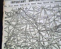
The front page has an 11 1/2 by 14 inch map: "IMPORTANT CONTEMPLATED OPERATIONS IN TENNESSEE." "The Great Battle Field of the Rebels Under General Joe Johnston and the Union Forces Under General Rosecrans." Relates heads on pg. 2: "The Coming Struggle" "Tenne... See More
Civil War map... Lincoln plans for his Emancipation Proclamation...
Item #702657
August 22, 1862
NEW YORK TRIBUNE, Aug. 22, 1862
* First Battle of Rappahannock Station close
* Abraham Lincoln prepares emancipation proclamation
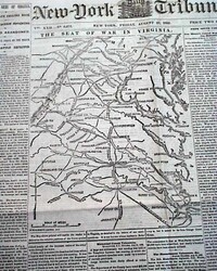
The front page is dominated by a large Civil War map headed: "THE SEAT OF WAR IN VIRGINIA." Among the column heads on the front page are: "General Pope Falling Back" "Stonewall Jackson Advancing" "Richmond Abandoned... See More
Letter from John Wesley... State of affairs in Pennsylvania...
Item #702561
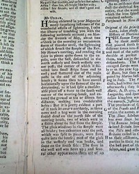
THE GENTLEMAN'S MAGAZINE, London, March, 1756 Among the articles within is a "Letter from Mr. Wesley Confirming the Yorkshire Earthquake", signed by him in type: John Wesley, the noted evangelist and founder of Methodism.Also: "Of the Cultivation of Exotics" which concerns the red cedar & other trees in America. Another article taking over 3 pages is "A Dia... See More
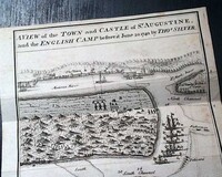
Terrific foldout map of St. Augustine, Florida, & vicinity... And a map of Chagre, Panama...
Item #702514
THE GENTLEMAN'S MAGAZINE, London, July, 1740
* Early and rare 18th century maps
* St. Augustine, Florida as English camp
* Atlantic Ocean - West Indies
Certainly the prime feature of this issue is the terrific foldout map titled: "A View of the Town and Castle of St. Augustine, & the English Camp before it June 20
... See More
* Early and rare 18th century maps
* St. Augustine, Florida as English camp
* Atlantic Ocean - West Indies
Certainly the prime feature of this issue is the terrific foldout map titled: "A View of the Town and Castle of St. Augustine, & the English Camp before it June 20
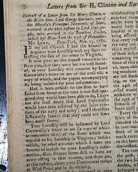
Cornwallis surrenders to Washington at Yorktown...
Item #702513
THE GENTLEMAN'S MAGAZINE, London, January, 1782 This issue contains the very historic report of the surrender of Lord Cornwallis at Yorktown, Virginia. An inside page has a nice report headed: "Extract of a Letter from Sir Henry Clinton" which begins: "...I had the honour to acquaint your Lordship with my fears respecting the fate of the army in Virginia. It no... See More
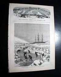
Special supplement focused on the Arctic Expedition of the H.M.SW. Discovery...
Item #701862
November 04, 1876
NEWS OF THE ARCTIC EXPEDITION, Supplement to The Illustrated London News, England, Nov. 4, 1876 This is a special issue with its own masthead themed on the Arctic Expedition of the H.M.S. Discovery.
Within are a tipped-in doublepage centerfold and 3 full page prints concerning the expedition, one of which is a: "Map Showing the Route of the Expedition".
Complete in 12 pages, grea... See More
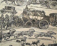
Famous illustrated daily newspaper...
Item #701796
August 02, 1877
THE DAILY GRAPHIC, New York, Aug. 2, 1877 This was one of the very few daily, illustrated newspapers in the United States, prints dominating at least 3 of the 8 pages.
The full front page shows: "Mail-Coaching In the Past & Present". Inside prints: "The Turco-Russian War--The Battle of Taghir" "Torpedo Warfare" "Map Illustrating the Relations of Other... See More
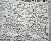
Huge Civil War map of North Carolina...
Item #701674
March 24, 1865
NEW YORK TRIBUNE, March 24, 1865
* Battle of Bentonville NC
* William T. Sherman
* Last days of the Civil War
The front page is dominated by a huge Civil War map headed: "FIELD OF OPERATIONS IN NORTH CAROLINA."
The balance of the front page is taken up with Civil War reports with heads including: "Another Rebel Victory ! " "An Engagement Between Sherman &am... See More
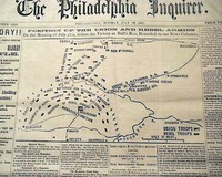
Terrific issue on the Battle of Bull Run...
Item #701667
July 22, 1861
THE PHILADELPHIA INQUIRER, July 22, 1861
* Battle of Bull Run - Manassas Virginia VA
* 1st major battle of the American Civil War
* Great issue for display w/ battle map
This is one of the more displayable issues we have found in recent years on the Battle of Bull Run.
The prime feature is a large map headed: "Position Of The Union And Rebel Armies On the Morning of July 21st, ... See More
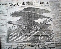
The fall of Richmond... Very graphic...
Item #701664
April 04, 1865
NEW-YORK TRIBUNE, April 4, 1865
* The fall of Richmond, the Confederate capital
* Terrific heraldic eagle & map for display
See the photos for this terrific and extremely graphic issue reporting the capture of Richmond, which essentially meant the end of the Confederacy. Lee would surrender to Grant at Appomattox just 5 days later.
The first column heads read: "VIR
... See More
* The fall of Richmond, the Confederate capital
* Terrific heraldic eagle & map for display
See the photos for this terrific and extremely graphic issue reporting the capture of Richmond, which essentially meant the end of the Confederacy. Lee would surrender to Grant at Appomattox just 5 days later.
The first column heads read: "VIR
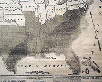
One of the best Civil War maps for display...
Item #701662
August 10, 1863
NEW YORK TRIBUNE, August 10, 1863
* Confederate States of America
See the photo for the terrific & huge front page map, taking close to two-thirds of the front page, headed: "THE REBEL CONFEDERACY AS CLAIMED IN 1861 AND AS IT IS NOW" showing how the rebel states have shrunk in two years.
If there was ever a definitive map issue from the Civil War this might well be it, a... See More
The Atlantic cable route across the ocean... Decline & fall of the Confederacy...
Item #701658
August 05, 1865
NEW YORK TRIBUNE, Aug. 5, 1865
* Atlantic cable route - U.S. map
* Southern Confederacy no more
Certainly the graphic appeal of this issue is the very large map showing the route of the Atlantic cable across the Atlantic Ocean, which also presents a nice map of the United States at this time with most of the area west of the Mississippi still as territories. Curiously there is n... See More
Map of the Hudson River region... Franklin on the exchange of prisoners...
Item #701099
GENTLEMAN'S MAGAZINE, London, January, 1778 * Rare Revolutionary War New York map
* Benjamin Franklin letter - Ethan Allen
Of great significance is the very nice foldout map headed: "Map of Hudson's River with the Adjacent Country", which shows from Crown Point & Ticonderoga, south to Philadelphia, & also from Long Island to Lake Ontario with consi... See More
Map of the Liverpool vicinity...
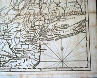
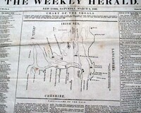
Item #701026
March 02, 1839
THE WEEKLY HERALD, New York, March 2, 1839 The front page is dominated by a map headed: "Chart OF The Shoals Outside the port of Liverpool..." showing the loss of several American ships from a recent gale.
Eight pages, never bound nor trimmed so it folds out to a single sheet, good condition.
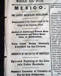
Much on the Battle of Monterrey, Mexico...
Item #700991
December 29, 1865
NEW YORK HERALD, Dec. 29, 1865 The front page has first column heads: "MEXICO" "Vera Cruz Being Strongly Fortified by the French" "Accounts of the Battle of Monterrey" "Splendid Fighting of tghe Liberals Under Escobedo" with more on this.
Included on the 2nd columns is a small map showing the town of Monterrey and vicinity.
Eight pages, very nice con... See More
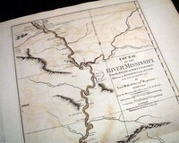
Huge map of the Mississippi River dated June 1, 1775...
Item #700671
January 01, 1783
COURSE of the RIVER MISSISSIPI [sic] from the Balise to Fort Chartres; Taken on an Expedition to the Illinois, in the latter end of the Year 1763 by Lieut. Ross of the 34th Regiment: Improved from the Surveys of that River made by the French".
London, Printed for Robt. Sayer No. 53 in 'Fleet Street, Published as the Act directs, 11 June 1775"
A noted map dealer
London, Printed for Robt. Sayer No. 53 in 'Fleet Street, Published as the Act directs, 11 June 1775"
A noted map dealer
From the "heyday" of Asbury Park and Ocean Grove, New Jersey...
Item #700298
July 28, 1888
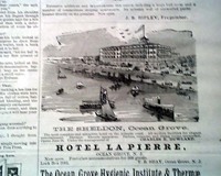
THE DAILY PRESS, Asbury Park & Ocean Grove, New Jersey, July 28, 1888
* From this tourist mecca of the 19th century
An interesting newspaper from these once-famous vacation meccas on the Jersey coast, containing various news of the day with an emphasis on tourism-related items. Page 2 has: "History of Asbury Park" taking ov
... See More
* From this tourist mecca of the 19th century
* Famous hotels in illustrated ads
An interesting newspaper from these once-famous vacation meccas on the Jersey coast, containing various news of the day with an emphasis on tourism-related items. Page 2 has: "History of Asbury Park" taking ov
1872 slave trade in Egypt...
Item #700186
October 16, 1872
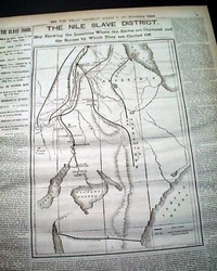
THE NEW YORK HERALD, Oct. 16, 1872
* Slavery in Nineteenth Century Egypt
Page 5 has a a large map headed: "THE NILE SLAVE DISTRICT" and more. Also a one column heading: "THE SLAVE TRADE" with many subheads. (see images)
Complete with all 12 pages, nice condition.
Civil War map shows from Columbus, Ohio to Northern Tennessee...
Item #700051
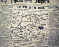
September 04, 1862
THE PHILADELPHIA INQUIRER, Sept. 4, 1862 The front page features a nice Civil War map with a heading in very large letters: "THE WAR IN THE WEST" with subhead: "Map of Cincinnati, Covington, and the adjacent Country--Showing the Route of the Rebel Advance into Kentucky".
Among the one column war heads are: "Our Army Falls Back to Washington" "The Traitors ... See More
Huge Civil War map dominates the front page...
Item #700000
October 18, 1862
THE PHILADELPHIA INQUIRER, Oct. 18, 1862
* Large Civil War map
About two-thirds of the front page is taken up with a huge & very detailed map headed: "FIELD OF MILITARY OPERATIONS IN MARYLAND AND VIRGINIA" with a subhead.
There are a few column heads also: "The Reconnaissance to Charlestown" "Return of Our Forces To Bolivar Heights" "Object of t... See More
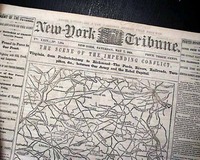
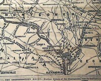
Huge Civil War map is very displayable...
Item #699323
May 07, 1864
NEW YORK TRIBUNE, May 7, 1864
* Battle of Spotsylvania (EVE)
* Robert E. Lee & large map
Most of the front page is taken up with a huge map headed: "THE SCENE OF THE IMPENDING CONFLICT. Virginia from Fredericksburg to Richmond--The Fords, Rivers, Railroads, Turnpikes, etc. between Our Army & the Rebel Capital." Half of the first column is taken up with related ... See More

Homer's "Seesaw--Gloucester... American baseball in London...
Item #699092
September 12, 1874
HARPER'S WEEKLY, New York, September 12, 1874
* Famous Winslow Homer print
Although there are many very nice prints within, the most desired is the full page print by Winslow Homer: "Seesaw--Gloucester, Massachusetts".
Also within is a full page: "The American Baseball Players in England--Match between the Red Stockings and the Athletics..." plus a half ... See More
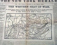
The Civil War in the West, with a map...
Item #699021
December 10, 1861
NEW YORK HERALD, Dec. 10, 1861
* Midwestern Civil War map
The front page features a nice & detailed Civil War map with a large heading: "THE WESTERN SEAT OF WAR" with a much more detailed subhead. The front page also has some nice first column heads including: "The Struggle In The West" "Strategic Positions Held by the Rebels..." "The Feeling in Kentuck... See More
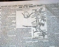
The Monitor vs. the Merrimac...
Item #699020
March 10, 1862
NEW YORK DAILY TRIBUNE, March 10, 1862
* Battle of Hampton Roads, Virginia
* Battle of the Monitor and Merrimack (CSS Virginia)
* American Civil War ironclads
The back page contains two nice Civil War maps headed: "Fernandina, Florida, and Vicinity" and "Scene of Burnside's Operations in North Carolina" as seen in the photos, with not only related one column ... See More
British Jew Bill... Engraving of a church in Charleston...
Item #698972
THE GENTLEMAN'S MAGAZINE, London, June, 1753
* Early Charleston SC church print
* The British Jew Bill - Judaica
This issue contains a great full page print of: "St. Philip's Church in Charles Town, South Carolina" with just a small bit of text on it on the facing page reading: "The church is esteemed one of the most regular & complete structures of
... See More
* Early Charleston SC church print
* The British Jew Bill - Judaica
This issue contains a great full page print of: "St. Philip's Church in Charles Town, South Carolina" with just a small bit of text on it on the facing page reading: "The church is esteemed one of the most regular & complete structures of
If you are searching for a newspaper from a specific date, please note that we have a vast selection available for purchase by using the date picker on our
gifts and birthday newspapers page.
An Inside Look
Timothy Hughes Rare &
Early Newspapers…
A special thank you goes out
to the staff of WGRC!
to the staff of WGRC!
History's Newsstand Blog
- June 19, 1865 – The historical foundation of “Juneteenth”…
- Snapshot June, 1875 – Winslow Homer…
- The June, 2025 Newsletter from Timothy Hughes Rare & Early Newspapers…
- Where game history, moral philosophy, and educational theory collide…
Timothy Hughes Rare & Early Newspapers
P.O. Box 3636
Williamsport, PA 17701
Phone: 1-570-326-1045
E-mail: info@rarenewspapers.com
Hours
Weekdays, 7:30 - 4 (ET)
Full Contact Information
P.O. Box 3636
Williamsport, PA 17701
Phone: 1-570-326-1045
E-mail: info@rarenewspapers.com
Hours
Weekdays, 7:30 - 4 (ET)
Full Contact Information

