
Other Potential Titles... |
|
Note: In addition to what may or may not be shown below, issues may be available for this date which have yet to be listed on our website. View Potential Titles for 01/01/1861 Due to the size of our inventory, it is possible we still may have what you are looking for. Please call (570-326-1045) or send your request to info@rarenewspapers.com. |
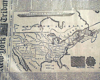
Two front page Civil War maps...
Item #706402
February 15, 1862
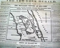
NEW YORK HERALD, Feb. 15, 1862
* Roanoke Island North Carolina
* Edenton & Elizabeth City NC
The front page is dominated by two nice Civil War maps, headed: "THE BRILLIANT VICTORY AT ROANOKE" and: "EDENTON AND ELIZABETH CITY".
First column heads report much on the war including events relating to the two maps. Some include: "The Integrity of the Union&qu... See More
Map of Charleston, South Carolina...
Item #705321
January 05, 1862
NEW YORK HERALD, Jan. 5, 1862 The front page features a large Civil War map headed: "IMPORTANT MOVEMENTS NEAR CHARLESTON, S. C." Among the one column headlines on the Civil War are: "IMPORTANT FROM THE SOUTH" "Operations on the Charleston and Savannah Railroad" "Seizure of the Station Near Charleston: "Desperate Battle and Defeat of the Rebels Near Por... See More
Two maps of operations around Vicksburg...
Item #705319
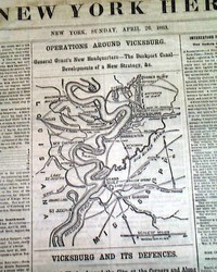
April 26, 1863
NEW YORK HERALD, April 26, 1863 The front page features two maps headed: "OPERATIONS AROUND VICKSBURG" and: "VICKSBURG AND IT'S DEFENSES" with much detail.
Among the front page one column headlines on the Civil War are: "NEWS FROM THE SOUTHWEST" "The Fight On The Coldwater River" "The Position and Strategy of General Grant" "NEWS FR... See More
Civil War map of the Savannah vicinity...
Item #705318
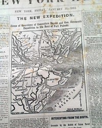
January 31, 1862
NEW YORK HERALD, Jan. 31, 1862 The front page features a nice map headed: "THE NEW EXPEDITION. Scene of Operations of Commodore Dupont & Gen. Sherman's Expedition to the Rear of Fort Pulaski".
Also on the front page is a wealth of war heads including: "Important From Savannah" "Splendid Naval Movement" "Interesting From the South" "The Fr... See More
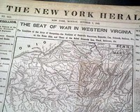
Large Civil War map on the front page...
Item #705314
October 07, 1861
NEW YORK HERALD, Oct. 7, 1861 The front page is dominated by a very large & very detailed Civil War map headed: "THE SEAT OF WAR IN WESTERN VIRGINIA". Plus many front page column heads on the war: "THE REBELLION" "Interview Between Generals McClellan & Banks" "Important News from the Cherokee Nation" "The Scene of War in Western Virginia&q... See More
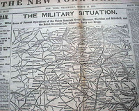
Large & displayable Civil War map...
Item #705313
March 15, 1865
NEW YORK HERALD, March 15, 1865 The front page features a huge & extremely detailed Civil War map headed: "THE MILITARY SITUATION. Scene of Present Operations of the Union Generals Grant, Sherman, Sheridan, and Schofield & the Rebels Generals Lee, Johnston, Early and Bragg." The map shows from Lynchburg to Wilmington, N. Carolina; to Columbia, Georgia; to Petersburg, Va.
A... See More
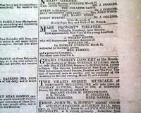
John Wilkes Booth 3 years before his notoriety...
Item #704904
March 17, 1862
NEW YORK TRIBUNE, March 17, 1862
* John Wilkes Booth theater ad
* Civil War original reporting
The front page contains one of the fascinating tidbits of history which delight collectors, in this case an inconspicuous advertisement for a theatrical production of Richard III at the Mary Provost Theater in New York--starring John Wilkes Booth. See the photo below for the complete ... See More
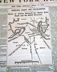
Map of Charleston Harbor...
Item #704753
April 13, 1863
NEW YORK HERALD, April 13, 1863
* First Battle of Charleston Harbor - South Carolina
The front page features a nice Civil War map headed: "OPENING FIGHT OFF CHARLESTON - Scene of Action Between the Union Iron-Clads & the Rebel Batteries".
Among the first column heads: "The Fight At Charleston" "The Keokuk Destroyed by a Torpedo" "Tremendous Fire of the... See More
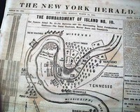
Map shows details of Columbus, Kentucky...
Item #704752
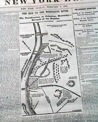
February 09, 1862
NEW YORK HERALD, Feb. 9, 1862
* Columbus, Kentucky Confederate fortifications map
The front page features a nice and detailed map headed: "The Key To The Mississippi River. The Fortifications at Columbus, Kentucky--Strength of the Position."
The balance of the front page is taken up with various Civil War reports with column heads including: "The Rebel Defences of Colum... See More
Two Civil War maps: front page and back page...
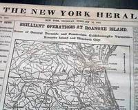
Item #704622
February 13, 1862
NEW YORK HERALD, Feb. 13, 1862
* Battle of Roanoke Island w/ map
* Ambrose Burnside & Louis M. Goldsborough
Taking close to half of the front page is a great map: "Brilliant Operations At Roanoke Island -- Scene of General Burnside and Commodore Goldsborough's Victories--Roanoke Island & Elizabeth City." The map and reports take all of the front page and conclud... See More
Huge front page Tennessee Battle map...
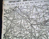
Item #702879
April 21, 1863
THE NEW YORK HERALD, April 21, 1863
* Large Tennessee Civil War map
* Battle of Suffolk - Virginia
The front page has an 11 1/2 by 14 inch map: "IMPORTANT CONTEMPLATED OPERATIONS IN TENNESSEE." "The Great Battle Field of the Rebels Under General Joe Johnston and the Union Forces Under General Rosecrans." Relates heads on pg. 2: "The Coming Struggle" "Tenne... See More
Civil War map... Lincoln plans for his Emancipation Proclamation...
Item #702657
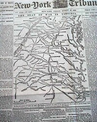
August 22, 1862
NEW YORK TRIBUNE, Aug. 22, 1862
* First Battle of Rappahannock Station close
* Abraham Lincoln prepares emancipation proclamation
The front page is dominated by a large Civil War map headed: "THE SEAT OF WAR IN VIRGINIA." Among the column heads on the front page are: "General Pope Falling Back" "Stonewall Jackson Advancing" "Richmond Abandoned... See More
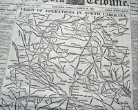
Huge Civil War map of North Carolina...
Item #701674
March 24, 1865
NEW YORK TRIBUNE, March 24, 1865
* Battle of Bentonville NC
* William T. Sherman
* Last days of the Civil War
The front page is dominated by a huge Civil War map headed: "FIELD OF OPERATIONS IN NORTH CAROLINA."
The balance of the front page is taken up with Civil War reports with heads including: "Another Rebel Victory ! " "An Engagement Between Sherman &am... See More
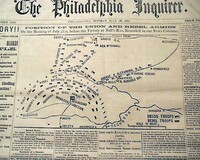
Terrific issue on the Battle of Bull Run...
Item #701667
July 22, 1861
THE PHILADELPHIA INQUIRER, July 22, 1861
* Battle of Bull Run - Manassas Virginia VA
* 1st major battle of the American Civil War
* Great issue for display w/ battle map
This is one of the more displayable issues we have found in recent years on the Battle of Bull Run.
The prime feature is a large map headed: "Position Of The Union And Rebel Armies On the Morning of July 21st, ... See More
The fall of Richmond... Very graphic...
Item #701664
April 04, 1865
NEW-YORK TRIBUNE, April 4, 1865
* The fall of Richmond, the Confederate capital
* Terrific heraldic eagle & map for display
See the photos for this terrific and extremely graphic issue reporting the capture of Richmond, which essentially meant the end of the Confederacy. Lee would surrender to Grant at Appomattox just 5 days later.
The first column heads read: "VIR
... See More
* The fall of Richmond, the Confederate capital
* Terrific heraldic eagle & map for display
See the photos for this terrific and extremely graphic issue reporting the capture of Richmond, which essentially meant the end of the Confederacy. Lee would surrender to Grant at Appomattox just 5 days later.
The first column heads read: "VIR
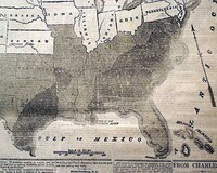
One of the best Civil War maps for display...
Item #701662
August 10, 1863
NEW YORK TRIBUNE, August 10, 1863
* Confederate States of America
See the photo for the terrific & huge front page map, taking close to two-thirds of the front page, headed: "THE REBEL CONFEDERACY AS CLAIMED IN 1861 AND AS IT IS NOW" showing how the rebel states have shrunk in two years.
If there was ever a definitive map issue from the Civil War this might well be it, a... See More
The Atlantic cable route across the ocean... Decline & fall of the Confederacy...
Item #701658
August 05, 1865
NEW YORK TRIBUNE, Aug. 5, 1865
* Atlantic cable route - U.S. map
* Southern Confederacy no more
Certainly the graphic appeal of this issue is the very large map showing the route of the Atlantic cable across the Atlantic Ocean, which also presents a nice map of the United States at this time with most of the area west of the Mississippi still as territories. Curiously there is n... See More
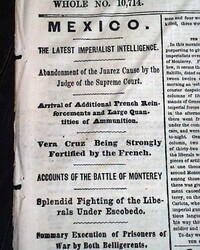
Much on the Battle of Monterrey, Mexico...
Item #700991
December 29, 1865
NEW YORK HERALD, Dec. 29, 1865 The front page has first column heads: "MEXICO" "Vera Cruz Being Strongly Fortified by the French" "Accounts of the Battle of Monterrey" "Splendid Fighting of tghe Liberals Under Escobedo" with more on this.
Included on the 2nd columns is a small map showing the town of Monterrey and vicinity.
Eight pages, very nice con... See More
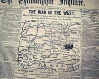
Civil War map shows from Columbus, Ohio to Northern Tennessee...
Item #700051
September 04, 1862
THE PHILADELPHIA INQUIRER, Sept. 4, 1862 The front page features a nice Civil War map with a heading in very large letters: "THE WAR IN THE WEST" with subhead: "Map of Cincinnati, Covington, and the adjacent Country--Showing the Route of the Rebel Advance into Kentucky".
Among the one column war heads are: "Our Army Falls Back to Washington" "The Traitors ... See More
Huge Civil War map dominates the front page...
Item #700000
October 18, 1862
THE PHILADELPHIA INQUIRER, Oct. 18, 1862
* Large Civil War map
About two-thirds of the front page is taken up with a huge & very detailed map headed: "FIELD OF MILITARY OPERATIONS IN MARYLAND AND VIRGINIA" with a subhead.
There are a few column heads also: "The Reconnaissance to Charlestown" "Return of Our Forces To Bolivar Heights" "Object of t... See More
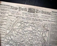
Huge Civil War map is very displayable...
Item #699323
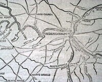
May 07, 1864
NEW YORK TRIBUNE, May 7, 1864
* Battle of Spotsylvania (EVE)
* Robert E. Lee & large map
Most of the front page is taken up with a huge map headed: "THE SCENE OF THE IMPENDING CONFLICT. Virginia from Fredericksburg to Richmond--The Fords, Rivers, Railroads, Turnpikes, etc. between Our Army & the Rebel Capital." Half of the first column is taken up with related ... See More
The Civil War in the West, with a map...
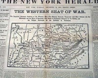
Item #699021
December 10, 1861
NEW YORK HERALD, Dec. 10, 1861
* Midwestern Civil War map
The front page features a nice & detailed Civil War map with a large heading: "THE WESTERN SEAT OF WAR" with a much more detailed subhead. The front page also has some nice first column heads including: "The Struggle In The West" "Strategic Positions Held by the Rebels..." "The Feeling in Kentuck... See More
The Monitor vs. the Merrimac...
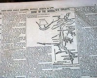
Item #699020
March 10, 1862
NEW YORK DAILY TRIBUNE, March 10, 1862
* Battle of Hampton Roads, Virginia
* Battle of the Monitor and Merrimack (CSS Virginia)
* American Civil War ironclads
The back page contains two nice Civil War maps headed: "Fernandina, Florida, and Vicinity" and "Scene of Burnside's Operations in North Carolina" as seen in the photos, with not only related one column ... See More

Map of Port Hudson, and military illustrations inside...
Item #698608
March 31, 1863
NEW YORK TRIBUNE, March 31, 1863
* Pre-Siege of Port Hudson - Louisiana
* American Civil War original map
The front page features a nice & detailed map headed: "Map Of Port Hudson" along the Mississippi.
Also front page column heads: "Naval Engagement at Port Hudson" "The Mississippi Abandoned & Destroyed" "Union Victory at Berwick's Bay... See More
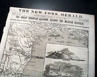
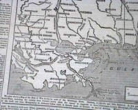
Huge front page map shows much of Texas...
Item #698599
November 30, 1861
NEW YORK HERALD, Nov. 30, 1861 An extremely decorative issue, as the entire front page is taken up with a huge map headed: "THE GREAT EUROPEAN ALLIANCE AGAINST THE MEXICAN REPUBLIC" with a subhead: "The Gulf Slope of Mexico--The Harbor of Vera Cruz and the National Road to the Capital--Scene of Operations of the English, French and Spanish Expedition." with the map showing much... See More
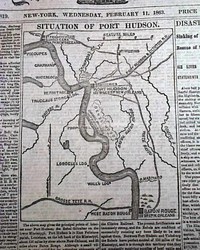
Civil War map of Port Hudson, Louisiana...
Item #698594
February 11, 1863
NEW YORK TRIBUNE, Feb. 11, 1863
* Port Hudson, Louisiana map
* Lebanon TN Tennessee
* Sabine Pass - Galveston TX Texas
The front page is dominated by a Civil War map titled: "Situation Of Port Hudson" which shows the vicinity as well, from Baton Rouge to the south to St. Francisville & Bayou Sara to the north.
Many one column war-related heads as well including: "... See More
Fine issue on the Monitor vs. the Merrimac...
Item #698508
March 10, 1862
NEW YORK HERALD, March 10, 1862
* Battle of Hampton Roads, Virginia
* Battle of the Monitor and Merrimack (CSS Virginia)
* Civil War ironclads
Front page first column heads report on the most famous naval battle of the Civil War: "Important From Fortress Monroe" "The Merrimac Out of Norfolk" "Tremendous Naval Conflict" "The Union Frigate Cu
... See More
* Battle of Hampton Roads, Virginia
* Battle of the Monitor and Merrimack (CSS Virginia)
* Civil War ironclads
Front page first column heads report on the most famous naval battle of the Civil War: "Important From Fortress Monroe" "The Merrimac Out of Norfolk" "Tremendous Naval Conflict" "The Union Frigate Cu
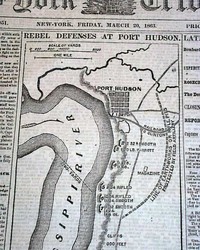
Civil War map on the rebel defenses at Port Hudson...
Item #698505
March 20, 1863
NEW YORK TRIBUNE, March 20, 1863
* Port Hudson, Louisiana map
* Battle of Kelly's Ford - Virginia
The front page is dominated by a nice & detailed Civil War map headed: "REBEL DEFENSES AT PORT HUDSON". Among the column heads on the Civil War are: "Late Rebel News" "Averill's Cavalry Expedition" "Rosecrans on the War Patch" "Clos... See More
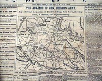
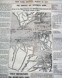
Civil War map shows advance of General Hooker's army...
Item #698504
May 02, 1863
PHILADELPHIA INQUIRER, May 2, 1863 The front page is dominated by a nice & detailed Civil War map headed: "THE ADVANCE OF GEN. HOOKER'S ARMY. Map Showing the Position of Fredericksburg, Port Royal, Bowling Green, Warrenton, and adjacent country." Plus there are many front page column heads on the Civil War as seen in the photos.
Eight pages, never bound nor trimmed, minima... See More
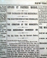
Monitor versus Merrimac... Map of New Madrid...
Item #698416
March 15, 1862
NEW YORK TRIBUNE, March 15, 1862
* Battle of Hampton Roads, Virginia
* Battle of the Monitor and Merrimack (CSS Virginia)
* Civil War ironclads
Page 5 contains some historic one column headlines including: "The Damages To The Merrimac," "The Condition of the Minnesota," "The Merrimac Hemmed In," "The War In the South-West," "... See More
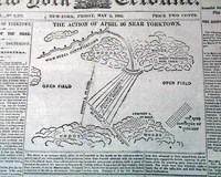
Yorktown siege.... New Orleans falls...
Item #698349
May 02, 1862
NEW YORK TRIBUNE, May 2, 1862
* Siege of Yorktown
* Fall of New Orleans
* Fort Macon North Carolina
The front page is dominated by a nice Civil War map headed: "The Action of April 26 Near Yorktown" which is more of a diagram of the battle.
Among the front page one column heads are: "Fall Of Fort Macon" "The Surrender of New Orleans" "Graceful but... See More
Large Civil War map of Virginia: Battle of Spotsylvania...
Item #698341
May 16, 1864
NEW YORK TRIBUNE, May 16, 1864
* Battle of Spotsylvania Court House
* Ulysses S. Grant vs. Robert E. Lee
* Civil War Overland Campaign w/ map
Over half of the front page is taken up with a large & detailed Civil War map headed: "GEN. GRANT'S ADVANCE TO RICHMOND."
Among the first column heads on the war are: "THE GREAT CONTEST" "Gen. Lee's Retreat... See More
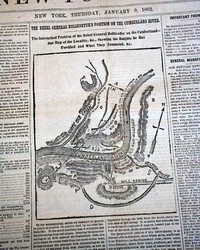
Map shows the Cumberland River...
Item #698337
January 09, 1862
NEW YORK HERALD, Jan. 9, 1862 The front page features a Civil War map headed: "The Rebel General Zollicoffer's Position On the Cumberland River.", plus several columns have war-related heads including: "Great Activity at the Headquarters of the Army" "Gen. Sherman's Report of Gen. Stevens' Operations on the Coosaw River" "Important From Western ... See More
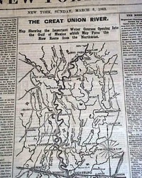
Large Civil War map of the Mississippi Valley...
Item #698333
March 08, 1863
NEW YORK HERALD, March 8, 1863 The front page features a large map headed: "THE GREAT UNION RIVER..." showing the Mississippi and tributaries from Moon Lake to the Gulf of Mexico.
Among the front page column heads on the war: "Important Military & Naval Movements on the Mississippi" "Tremendous Efforts of the Unionists to Open Navigation to the Gulf" "... See More
Death of Commodore Uriah P. Levy... Large Civil War map...
Item #698135
March 24, 1862
NEW YORK HERALD, March 24, 1862
* Uriah P. Levy death (1st report)
* 1st Jewish commodore of U.S. Navy
* American Civil War - Jews
The most notable content within this issue is the very brief, but historic page 5 report of the death of Commodore (Admiral) Uriah P. Levy, the first U.S. Jewish Commodore, war of 1812 war hero, and credited as to having abolished the disciplinary procedu... See More
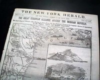
Huge front page map shows much of Texas...
Item #698117
November 30, 1861
NEW YORK HERALD, Nov. 30, 1861
* Gulf of Mexico coast map
* Texas - Mexico
An extremely decorative issue, as the entire front page is taken up with a huge map headed: "THE GREAT EUROPEAN ALLIANCE AGAINST THE MEXICAN REPUBLIC" with a subhead: "The Gulf Slope of Mexico--The Harbor of Vera Cruz and the National Road to the Capital--Scene of Operations of the English, Fren... See More
Huge Civil War map of the war in the Southwest...
Item #698090
May 31, 1862
NEW YORK TRIBUNE, May 31, 1862
* Siege of Corinth, Mississippi
* Confederate states map
Most of the front page is taken up with a huge Civil War map titled: "THE SEAT OF WAR IN THE SOUTH-WEST" with some column heads including: "The Capture of Corinth" "Another Rebel 'Skedaddle' " "Gen. Nelson in the Enemy's Camp" "Retreat... See More
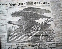
Civil War map of Virginia... First Battle of Rappahannock Station...
Item #696936
August 28, 1862
NEW YORK TRIBUNE, Aug. 28, 1862
* First Battle of Rappahannock Station
* General Stonewall Jackson
The front page features a large Civil War map headed: "The Field Of Operations In Virginia". Nice column heads on the war include: "The War In Virginia" 'The Intentions of Gen. Lee" "The Junction of the Armies" & more.
Eight pages, bit of foxi... See More
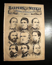
The Alabama delegation secedes from the Union...
Item #695406
February 09, 1861
HARPER'S WEEKLY, New York, Feb. 9, 1861
* Alabama delegation in U.S. Congress prints
* Secession from the Union - pre-Civil War
The full front page is a print of: "The Seceding Alabama Delegation In Congress" showing nine men. Text on the men takes over half of page 2.
Other prints within include: "Captain J. G. Foster, Engineer Corps U.S.A., On Duty at Fort Sumter... See More
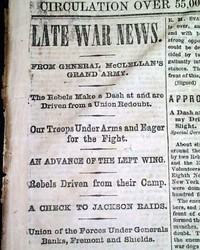
Front page Civil War reports... Back page map...
Item #695329
June 26, 1862
THE PHILADELPHIA INQUIRER, June 26, 1862 The back page features a very nice: "Map Showing the New Route to New York, and its Connections" showing the Phila. area plus New York City & the places between.
The front page has column heads on the Civil War including: "LATE WAR NEWS" "From General McCellan's Grand Army" "A Check to Jackson Raids"
... See More
The front page has column heads on the Civil War including: "LATE WAR NEWS" "From General McCellan's Grand Army" "A Check to Jackson Raids"
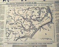
Two maps of Pamlico Sound & environs...
Item #695328
January 29, 1862
PHILADELPHIA INQUIRER, Jan. 29, 1862 The front page has two Civil War maps, one: "Showing the Position of Hatteras Inlet and Roanoke Island" and the other a: "Diagram Showing Hatteras Inlet & Where the Vessels Were Wrecked".
Many front page column heads on the Civil War including: "War Against Treason!" "Great Difficulty In Passing Hatteras Bar" &... See More
Map of Harper's Ferry, West Virginia...
Item #695310
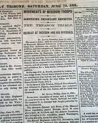
June 15, 1861
NEW YORK TRIBUNE, June 15, 1861
* Harpers Ferry, West Virginia
* Confederates evacuation
* Prelude to Battle of Bull's Run
The format of this title at this time was advertisements on the front page with the wealth of Civil War reporting on inside pages.
A feature of this issue is the nice & detailed back page map headed: "Harper's Ferry And The Region Ro... See More
Much on the Civil War... Civil War map of Acquia Creek...
Item #695307
June 01, 1861
NEW YORK TRIBUNE, June 1, 1861
* Battle of Aquia Creek Civil War map
* Union Navy gunboats vs. Confederate batteries
* One of the first battles of the war
The format of this title at this time was advertisements on the front page with the wealth of Civil War reporting on inside pages.
The back page includes a Civil War map headed: "Acquia Creek and Its Environs" wit... See More
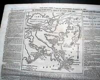
Map of Port Royal, South Carolina... Slaver is convicted...
Item #695306
November 15, 1861
NEW YORK TRIBUNE, Nov. 15, 1861 The format of this title at this time was advertisements on the front page with the wealth of Civil War reporting on inside pages.
The back page features a nice Civil War map headed: "PORT ROYAL" and captioned at the bottom of it: "Scene And Plan of The Battle" followed by descriptive text.
Much war reporting inside with column heads incl... See More
Huge map dominates the front page...
Item #695304
May 05, 1863
NEW YORK TRIBUNE, May 5, 1863
* Second Battle of Fredericksburg w/ map
* Chancellorsville campaign - Virginia
The front page is dominated by a huge Civil War map headed: "THE SITUATION IN VIRGINIA" which takes about half of the page.
Many front page column heads including: "Advance Of The Potomac Army" "The Enemy In Retreat" "Left Wing Behind Freder... See More
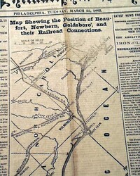
Railroad connections in the South...
Item #695277
March 25, 1862
PHILADELPHIA INQUIRER, March 25, 1862
* First Battle of Kernstown
* General James Shields
* Beaufort NC North Carolina
The front page features a nice map headed: "Map Showing the Position of Beaufort, Newbern, Goldsboro, and Their Railroad Connections".
Many column Civil War heads including: "THE REBELLION" "Latest From Winchester" "Stragglers Cap... See More

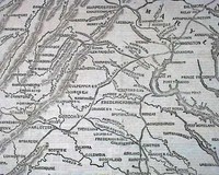
Two front page Civil War maps...
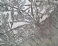
Item #695274
February 13, 1862
PHILADELPHIA INQUIRER, Feb. 13, 1862 A very graphic & displayable issue as the front page features not one but two Civil War maps, one captioned: "Albemarle Sound & the Point of Attack of the Federal Fleet", with related text, and the other headed: "Roanoke Island".
Both the first and last columns have nice stacks of Civil War headlines including: "VICTORY! ... See More
Huge Civil War map of the Richmond vicinity...
Item #695272
May 24, 1862
THE PHILADELPHIA INQUIRER, May 24, 1862
* Battle of Drewry's Bluff
* Fort Darling attack
* Huge map for display
As seen in the photos, this issue is dominated by the great & huge Civil War front page map headed: "APPROACH OF THE UNION ARMIES ON THE REBEL CAPITAL--Scene of General McClellan's Triumphal March up the Peninsula, & Commander Rodgers' Terr
... See More
* Battle of Drewry's Bluff
* Fort Darling attack
* Huge map for display
As seen in the photos, this issue is dominated by the great & huge Civil War front page map headed: "APPROACH OF THE UNION ARMIES ON THE REBEL CAPITAL--Scene of General McClellan's Triumphal March up the Peninsula, & Commander Rodgers' Terr
Map showing the approach to New Orleans...
Item #695266
October 16, 1861
NEW YORK TRIBUNE, Oct. 16, 1861
* Lower Mississippi River map
The format of this title at this time was advertisements on the front page with the wealth of Civil War reporting on inside pages.
The back page features a very detailed Civil War map headed: "The Approaches To New Orleans---Scene Of The Alleged Naval Fight", with some war-related reports as well.
Page
... See More
Page
Civil War map of the Mississippi...
Item #695262
May 23, 1862
NEW YORK TIMES, May 23, 1862
* Vicksburg, Mississippi vicinity map
* Battle at Princetown Court House
The front page is dominated by a very nice Civil War map headed: "FARRAGUT'S NAVAL OPERATIONS ON THE MISSISSIPPI RIVER - Map Showing the Situation of Vicksburg, Miss., Indicating the Cotton Plantations in the Vicinity & Exhibiting the Topography of the Region.... See More
If you are searching for a newspaper from a specific date, please note that we have a vast selection available for purchase by using the date picker on our
gifts and birthday newspapers page.
An Inside Look
Timothy Hughes Rare &
Early Newspapers…
A special thank you goes out
to the staff of WGRC!
to the staff of WGRC!
History's Newsstand Blog
- June 19, 1865 – The historical foundation of “Juneteenth”…
- Snapshot June, 1875 – Winslow Homer…
- The June, 2025 Newsletter from Timothy Hughes Rare & Early Newspapers…
- Where game history, moral philosophy, and educational theory collide…
Timothy Hughes Rare & Early Newspapers
P.O. Box 3636
Williamsport, PA 17701
Phone: 1-570-326-1045
E-mail: info@rarenewspapers.com
Hours
Weekdays, 7:30 - 4 (ET)
Full Contact Information
P.O. Box 3636
Williamsport, PA 17701
Phone: 1-570-326-1045
E-mail: info@rarenewspapers.com
Hours
Weekdays, 7:30 - 4 (ET)
Full Contact Information

