
Other Potential Titles... |
|
Note: In addition to what may or may not be shown below, issues may be available for this date which have yet to be listed on our website. View Potential Titles for 01/01/1600 Due to the size of our inventory, it is possible we still may have what you are looking for. Please call (570-326-1045) or send your request to info@rarenewspapers.com. |
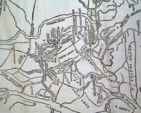
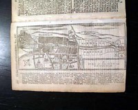
Very large Civil War map show the Beaufort vicinity...
Item #672809
January 11, 1862
NEW YORK HERALD, Jan. 11, 1862 Most of the front page is taken up with a huge Civil War map headed: "The Scene Of Operations at Port Royal Ferry..." with a subhead. The map shows much detail of the Beaufort vicinity.
There are also first column heads: "Additional Details of the Affair at Port Royal Ferry" and "Our Map of the Scene of General Stevens' Operations&... See More
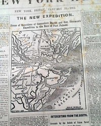
Civil War map of the Savannah vicinity...
Item #672808
January 31, 1862
NEW YORK HERALD, Jan. 31, 1862 The ftpg. features a nice map headed: "THE NEW EXPEDITION. Scene of Operations of Commodore Dupont & Gen. Sherman's Expedition to the Rear of Fort Pulaski".
Also on the ftpg. is a wealth of war heads including: "Important From Savannah" "Splendid Naval Movement" "Interesting From the South" "The French Leavi... See More
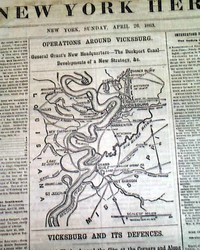
Two maps of operations around Vicksburg...
Item #672806
April 26, 1863
NEW YORK HERALD, April 26, 1863 The front page features two maps headed: "OPERATIONS AROUND VICKSBURG" and: "VICKSBURG AND IT'S DEFENSES" with much detail.
Among the ftpg. one column headlines on the Civil War are: "NEWS FROM THE SOUTHWEST" "The Fight On The Coldwater River" "The Position and Strategy of General Grant" "NEWS FROM TE... See More
Map of Charleston, South Carolina...
Item #672491
January 05, 1862
THE NEW YORK HERALD, Jan. 5, 1862 The front page features a large Civil War map headed: "IMPORTANT MOVEMENTS NEAR CHARLESTON, S. C." Among the one column headlines on the Civil War are: "IMPORTANT FROM THE SOUTH" "Operations on the Charleston and Savannah Railroad" "Seizure of the Station Near Charleston
* Desperate Battle and Defeat of the Rebels Near Por... See More
With American content...
Item #672375
THE GENTLEMAN'S MAGAZINE, London, February, 1750 Among the articles within: "Whence Differences in the same Climate--Sea Lions" includes two illustrations of sea lions. Another article is titled: "Of the Crocodile" followed by: "Flourishing Settlement in Nova Scotia--Plants There" which is accompanied by a full page plate of various plants: &qu
... See More
Map of Germany... The Mississippi River...
Item #672359
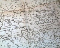
THE GENTLEMAN'S MAGAZINE, London, January, 1761 * Nice foldout map of Germany and vicinity
* Concerning the French & Indian War
An article: "Thoughts on the Present Posture of Affairs" includes some discussion concerning America, and includes: "...Hence it is evident that as North America was the bone of contention, Great Britain must not be induced to par... See More
Report from the Churchill River in Canada...
Item #672277
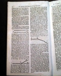
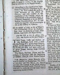
THE GENTLEMAN'S MAGAZINE, London, England, March, 1743 One of the articles is titled: "Of the Effects of Cold at Pr. of Wales' in Churchill River in Hudson's Bay..." which is present-day Canada. This article takes over a full page.
Among the other articles in this issue are: "No Writers for the Ministry" and "Reasons for a Steady Opposition". N
... See More
Among the other articles in this issue are: "No Writers for the Ministry" and "Reasons for a Steady Opposition". N
Large & displayable Civil War map...
Item #672028
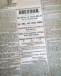
March 15, 1865
NEW YORK HERALD, March 15, 1865
* Confederates falling apart
* Nearing the end of war
The ftpg. features a huge & extremely detailed Civil War map headed: "THE MILITARY SITUATION. Scene of Present Operations of the Union Generals Grant, Sherman, Sheridan, and Schofield & the Rebels Generals Lee, Johnston, Early and Bragg." The map shows from Lynchburg to Wilmington, ... See More
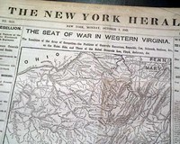
Large Civil War map on the front page...
Item #672023
October 07, 1861
NEW YORK HERALD, Oct. 7, 1861 The front page is dominated by a very large & very detailed Civil War map headed: "THE SEAT OF WAR IN WESTERN VIRGINIA". Plus many ftpg. column heads on the war: "THE REBELLION" "Interview Between Generals McClellan & Banks" "Important News from the Cherokee Nation" "The Scene of War in Western Virginia" ... See More
The international boat race of 1872...
Item #671972
August 28, 1869
THE NEW YORK HERALD, Aug. 28, 1869
* The international boat race
* Atalanta vs. London boat club crew
* The River Thames - London w/ map
Page 3 has a four column map with headline: "THE INTERNATIONAL ROWING MATCH" and more. Also one column headings: "THE GREAT BOAT RACE" "The Match Between the Atalanta and London Rowing Club Crews Contested on the Thames" &quo... See More
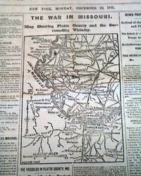
The Civil War in Missouri, with a map...
Item #671828
December 23, 1861
NEW YORK HERALD, Dec. 23, 1861 The front page features a map headed: "THE WAR IN MISSOURI - Map Showing Platte County & the Surrounding Vicinity".
Among the ftpg. column heads on the Civil War are The Troubles in Platte County, Mo." "How They Affect Gen. Hunter's Dept." "General Hunter's Ultimatum" "The Rebels Attempt to Drive the Union Troops f... See More
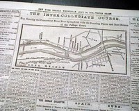
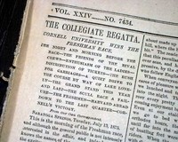
1873 Intercollegiate Regatta... rowing...
Item #671647
July 16, 1875
THE NEW YORK HERALD, July 16, 1873
* Intercollegiate Regatta
* Connecticut River
* Springfield, Massachusetts
* Boat - rowing
The top of page 7 has a four column map headed: "THE INTER-COLLEGIATE COURSE" and more which shows area where the race was to be held with the college boarding places. (see) One column headings include: "THE SPRINGFIELD REGATTA" "A Rapid S... See More
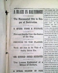
The Clay Street, Baltimore fire disaster of 1873...
Item #671633
July 26, 1873
NEW YORK HERALD, July 26, 1873 (with Supplement) Page 5 has one column headings that include: "A BLAZE IN BALTIMORE" "The Monumental City in Danger of Destruction" "A Spark For A Furnace" "One Hundred Houses Destroyed" "The Losses Estimated at a Million of Dollars" and more with a nice, detailed map of the stricken area.
Complete with 10 pag... See More
Battle of Mill Springs, Kentucky... Roanoke Island, North Carolina...
Item #671206
February 03, 1862
NEW YORK TRIBUNE, Feb. 3, 1862
* Battle of Mill Springs, Kentucky
* Roanoke Island, North Carolina
The back page has a map headed: "Plan Of The Battle of Mill Spring (Logan's Cross-Roads), Near Somerset, Ky., January 9, 1862". The bkpg. also has column heads: "The Battle of Mill Spring" "Additional Incidents of the Battle" "The Flight of the Rebe... See More

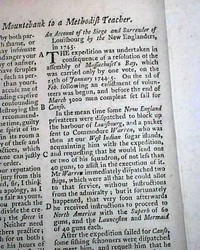
Oswego during the French & Indian War, with maps...
Item #670988
THE GENTLEMAN'S MAGAZINE, London, February, 1757
* Forts Oswego and Ontario
* French and Indian war with map
Among the inside pages is a quite lengthy & detailed article titled: "An Historical Account of American Affairs during the Two last years, with a particular journal of the Siege & Surrender of Oswego" with this text taking over six pages (see photo
... See More
* Forts Oswego and Ontario
* French and Indian war with map
Among the inside pages is a quite lengthy & detailed article titled: "An Historical Account of American Affairs during the Two last years, with a particular journal of the Siege & Surrender of Oswego" with this text taking over six pages (see photo
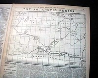
Charles Wilkes' Antarctica revisited in 1874... ...
Item #670918
June 08, 1874
NEW YORK HERALD, June 8, 1874
* American explorer Charles Wilkes
* Exploration of Antarctica revisited w/ map
The top half of page 3 has a map headed: "THE ANTARCTIC REGION" One column headings include: "WILKES' CONTINENT" "The Antarctic Land of the American Explorer Evaporated" and more.
Other news of the day. Complete in 12 pages, nice condition.... See More
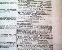
John Wilkes Booth 3 years before his notoriety...
Item #670358
March 17, 1862
NEW YORK TRIBUNE, March 17, 1862
* John Wilkes Booth theater ad
* Civil War original reporting
The front page contains one of the fascinating tidbits of history which delight collectors, in this case an inconspicuous advertisement for a theatrical production of Richard III at the Mary Provost Theater in New York--starring John Wilkes Booth. See the photo below for the complete a... See More
Civil War map of the war in Kentucky & Tennessee...
Item #670352
January 21, 1862
NEW YORK TRIBUNE, Jan. 21, 1862 With the front page taken up with ads, the feature is the back page war map headed: "THE WAR IN KENTUCKY & TENNESSEE" with related column heads, including; "Defeat of Zollicoffer's Army" "Fighting All Day" "Gen. Zollicoffer Killed" "Utter Rout of the Rebels" "Heavy Lossl On Both Sides" &... See More
Map of war events in Arkansas...
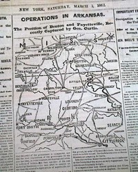
Item #670334
March 01, 1862
NEW YORK HERALD, March 1, 1862 The front page features a Civil War map headed: "OPERATIONS IN ARKANSAS - The Position of Benton & Fayetteville, Recently Capture by Gen. Curtis".
Among ftpg. column heads: "News From the South" "Jeff Davis' Message to the Rebel Congress" "The Despairing Cry of the Rebels" "The Rebel Leaders Have Attempted M... See More
Map shows portion of Kentucky, Tennessee, Alabama, & more...
Item #670330
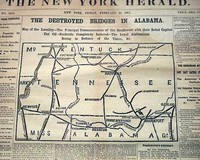
February 21, 1862
NEW YORK HERALD, Feb. 21, 1862 The front page is dominated by a nice Civil War map headed: "THE DESTROYED BRIDGES IN ALABAMA - Map of the Locality--The Principal Communication of the Southwest with Their Rebel Capital Cut Off--Nashville Completely Isolated--The Loyal Alabamians Rising in Defence of the Union"
Good column heads include: "Confirmation of the Reported Evacuation... See More
Two front page Civil War maps...
Item #670325
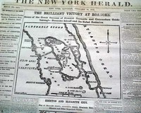
February 15, 1862
NEW YORK HERALD, Feb. 15, 1862 The front page is dominated by two nice Civil War maps, headed: "THE BRILLIANT VICTORY AT ROANOKE" and: "EDENTON AND ELIZABETH CITY".
First column heads report much on the war including events relating to the two maps. Some include: "The Integrity of the Union" "Brilliant Events in Pamlico Sound, on Pasquotank River, and in A... See More
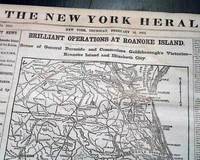
Two Civil War maps: front page and back page...
Item #670324
February 13, 1862
THE NEW YORK HERALD, Feb. 13, 1862
* Battle of Roanoke Island w/ map
* Ambrose Burnside & Louis M. Goldsborough
Taking close to half of the front page is a great map: "Brilliant Operations At Roanoke Island -- Scene of General Burnside and Commodore Goldsborough's Victories--Roanoke Island & Elizabeth City." The map and reports take all of the front page and conc... See More
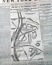
Map shows details of Columbus, Kentucky...
Item #670322
February 09, 1862
NEW YORK HERALD, Feb. 9, 1862 The ftpg. features a nice and detailed map headed: "The Key To The Mississippi River. The Fortifications at Columbus, Kentucky--Strength of the Position."
The balance of the ftpg. is taken up with various Civil War reports with column heads including: "The Rebel Defences of Columbus" "Columbus Considered Impregnable" "Demorali... See More
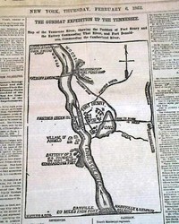
Map shows the Tennessee River Valley...
Item #670321
February 06, 1862
NEW YORK HERALD, Feb. 6, 1862 The ftpg. features a nice Civil War map headed: "The Gunboat Expedition Up The Tennessee. Map of the Tennessee River, Showing the Position of Fort Henry & the Battery Commanding That River, and Fort Donaldson, Commanding the Cumberland River."
Much of the ftpg. has various Civil War reports with one column heads including: "Important From Ten... See More
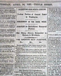
Huge Civil War map of an iron-clad fight...
Item #670319
April 14, 1863
NEW YORK HERALD, April 14, 1863
* First Battle of Charleston
* Ironclads warships clash
Although the front page has Civil War reports, including a small print of the military position, pages 2 & 3 have more on the Civil War including a huge Civil War map: "THE GREAT IRON-CLAD FIGHT - Scene Of Operations Off Charleston...".
There are great column heads: "SUMTE... See More
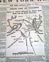
Map of Charleston Harbor...
Item #670318
April 13, 1863
NEW YORK HERALD, April 13, 1863
* First Battle of Charleston Harbor
The front page features a nice Civil War map headed: "OPENING FIGHT OFF CHARLESTON - Scene of Action Between the Union Iron-Clads & the Rebel Batteries".
Among the first column heads: "The Fight At Charleston" "The Keokuk Destroyed by a Torpedo" "Tremendous Fire of the Rebel Batt... See More
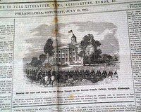
Front page war print and a page 3 war map...
Item #670028
July 19, 1862
THE SATURDAY EVENING POST, Philadelphia, July 19, 1862 A desired yet rather scarce title from during the Civil War, as the front page occasionally featured a Harper's Weekly-like Civil War print.
This issue features on the ftpg: "Hoisting the Stars & Stripes by the Union Troops on the Corona Female College, Corinth, Mississippi" with some detail. Page 3 features a Civil Wa... See More
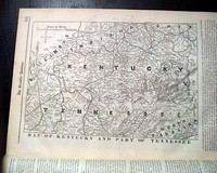
Nearly full page Civil War map...
Item #669628
February 22, 1862
SCIENTIFIC AMERICAN, New York, Feb. 22, 1862 Almost the entirety of page 3 is taken up with a great & very detailed Civil War map captioned: "Map of Kentucky And Part of Tennessee" with the balance of the page being text concerning it.
Also, over half of page2 is taken up with various military reports from the Civil War.
Sixteen pages, very nice condition.... See More
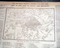
Khanate of Khivan campaign of 1873...
Item #669379
November 26, 1873
THE NEW YORK HERALD, Nov. 26, 1873
* Khivan campaign of 1873 w/ map
The top of page 4 has a four column map with headline: "Map Of The City Of Khiva And Environs" Also one column headings include: "KHIVA--NO. 5." "Bombardment Of Khiva" and more. (See)
Complete with 12 pages, nice condition.... See More
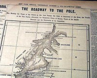
1873 Polaris expedition to North Pole..
Item #669244
October 01, 1873
NEW YORK HERALD, Oct. 1, 1873
* Polaris expedition to North Pole (hardships)
Page 5 has large map with headline: "THE ROADWAY TO THE POLE" and more. Also many one column headings include: "THE POLARIS" "Detailed Accounts of the Rescue of Buddington's Party" "Thrilling Narrative of Two Years of Peril by an Old Salt" "What Followed The Death Of... See More
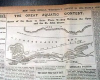
1871 Canada boat race....
Item #669221
August 23, 1871
THE NEW YORK HERALD, Aug. 23, 1871
* New Brunswick, Canada
* Kennebecasis River boat race
* St. John vs. Tyne, Newcastle crews
The top of page 3 has a three column map titled: "THE GREAT AQUATIC CONTEST" and more. Also one column headings: "THE ST. JOHN RACE" "The Crews In Tip-Top Condition" "About the Betting and Its Changes" and more. (see)
... See More
The university crew races on Lake Saratoga...
Item #669173
July 14, 1875
THE NEW YORK TIMES, July 14, 1875
* Intercollegiate Regatta w/ map
* Cornell University Big Red (Freshmen)
* Boat - rowing - Saratoga Lake
The top of the front page has one column headings: "THE COLLEGIATE REGATTA" "Cornell University Wins The Freshmen Race" and more. (see) Lengthy text takes up most of the front page and continues inside.
Other news of the day. ... See More
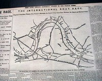
The great international boat race of 1869...
Item #669048
August 28, 1869
THE NEW YORK HERALD, Aug. 28, 1869
* The great international boat race
* Harvard vs. Oxford University
* The River Thames - London w/ map
Page 3 has a four column map with headline: "THE INTERNATIONAL BOAT RACE" and more. Also one column headings: "THE RACE" "The International Pull at the Oar" "The College Boys of Harvard (American) and Oxford (English) i... See More
Map relating to the coming Civil War...
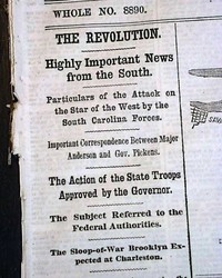
Item #668400
January 11, 1861
THE NEW YORK HERALD, Jan. 11, 1861
* Start of the Civil War ? w/ map
* Star of the West attacked
A pre-Civil War issue with a nice ftpg. map headed: "SAVANNAH AND ITS FORTIFICATIONS" (see). Fully half of the first column has heads relating to the coming Civil War, including: "The Revolution" "Highly Important News from the South" "Particulars of the ... See More
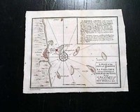
Map of Veracruz & the castle of San Juan...
Item #667390
THE GENTLEMAN'S MAGAZINE, London, May, 1740 The prime feature of this issue is the nice foldout map of Vera Cruz, Castle of San Juan, Port of New Spain titled: "A Plan of the City and Harbour of La Vera Cruz and the Castle of San Juan De Ulua, being the Key of Traffick and the Principal Port of New Spain", folding out to measure 6 1/4 by 7 1/2 inches, with hand-tinted highlight... See More
Nice map of portions of Canada...
Item #667291
THE GENTLEMAN'S MAGAZINE, London, March, 1758 Certainly the prime feature of this issue is the very nice & detailed foldout map titled: "A Plan of the City & Harbour of Louisburg; shewing that part of Gabarus Bay in which the English landed, also their Encampment during the Siege in 1745." Within this map is a large inset in the upper left which is: "A Map of the I... See More
Oswego during the French and Indian War with an in-text map...
Item #667290
THE GENTLEMAN'S MAGAZINE, London, February, 1757 * Forts Oswego and Ontario
* French and Indian war with map
Inside has is a quite lengthy article titled: "An Historical Account of American Affairs during the Two last years, with a particular journal of the Siege & Surrender of Oswego" with this text taking over six pages.
This text also includes a report headed &qu... See More

Map of Havana, Cuba...
Item #667199
THE GENTLEMAN'S MAGAZINE, London, April, 1762 Although typically missing from most issues, this magazine still contains the full page plate titled: "Plan of the City and Harbour of Havanna" which also includes a key as to the various points of interest.An article: "Weak State of the Island of Jamaica" but the map of Jamaica is lacking.
Near the back of the issue is... See More
Major event at Crown Point, the French & Indian War...
Item #667159
THE GENTLEMAN'S MAGAZINE, London, September, 1759
* Fort Crown Point - New York
* Field Marshall Jeffery Amherst
* french and Indian War
An inside page contains a great report on one of the more significant battles of the French & Indian War, headed: "Letter from Maj. Gen. Amherst to Mr. Secretary Pitt, dated Crown Point, August 5" which gives a day-by-day
... See More
* Fort Crown Point - New York
* Field Marshall Jeffery Amherst
* french and Indian War
An inside page contains a great report on one of the more significant battles of the French & Indian War, headed: "Letter from Maj. Gen. Amherst to Mr. Secretary Pitt, dated Crown Point, August 5" which gives a day-by-day
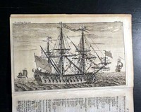
Terrific 18th century ship illustration...
Item #667124
GENTLEMAN'S MAGAZINE, London, July, 1748 Certainly a prime feature is the terrific, full page illustration of: "A Ship Of War" with considerable detail, and with most of the facing page having the "Explanation to a Ship of War of the third Rate with Rigging, &c., at Anchor".The "Explanation" numerically identifies 148 parts noted on the plates as well ... See More
Anti-Catholic sentiment... Much on the Jacobite Rebellion...
Item #667110
THE GENTLEMAN'S MAGAZINE, London, England, November, 1745 There is a tremendous amount of content concerning the Jacobite Rebellion with articles: "A Short Account of the Rebellion in 1715 continued" "Remarks on the Young Pretender's Declaration" and further on: "Progress of the Rebels" which takes 3 pages, and "Carlisle Taken by the Rebels"
... See More
Death of Jonathan Swift... Early printing of "God Save the King"... Battle charts...
Item #667109
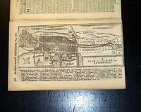
THE GENTLEMAN'S MAGAZINE, London, October, 1745 A highlight of this issue is the interesting and unusual full page engraving of: "A Plan of the City of Edinburgh" which has much detail, showing the castle as well, and includes a rather large key to various locations as well. Further on is a very detailed article: "Description of the City of Edinburgh".
Another si
... See More
Another si
Death of Jonathan Swift... Early printing of "God Save the King"... Battle charts...
Item #667108
THE GENTLEMAN'S MAGAZINE, London, October, 1745 A highlight of this issue is the interesting and unusual full page engraving of: "A Plan of the City of Edinburgh" which has much detail, showing the castle as well, and includes a rather large key to various locations as well. Further on is a very detailed article: "Description of the City of Edinburgh".
Another si
... See More
Another si
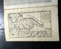
Creating the Mason-Dixon Line: map of America...
Item #666701
THE GENTLEMAN'S MAGAZINE, London, December, 1769* Early America map
* Pennsylvania and Maryland
* Mason and Dixon Line creation
Certainly the prime feature of this issue is the nice full page map of the Chesapeake region showing parts of Virginia, Maryland, Pennsylvania, New Jersey, and all of Delaware.
The inset in the lower right corner reads: "A Map of that Part of America wh... See More
Nice map of Jamaica...
Item #666213
THE GENTLEMAN'S MAGAZINE, London, April, 1762 This magazine still has the full page plate of "A Map Of the Island of Jamaica" which shows much detail. This map measures 5 by 8 inches and has tiny binding holes above the top margin, not touching the map. There is also a report which relates to it titled: "Weak State of the Island of Jamaica".There is also another art... See More
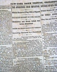
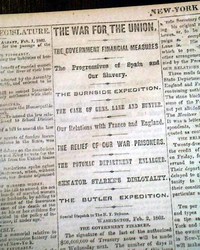
With a map of Savannah...
Item #660620
April 03, 1862
NEW YORK TRIBUNE, April 3, 1862
* Savannah, Georgia map
* Fort Pulaski
Among the column heads on the Civil War on inside pages are: "The War For The Union" "The Deportation of Slaves" "The Operations Near Savannah" "Official Report of Flag Officer Dupont" "The Rebels Utterly Demoralized" "Weak Stand by Ashby's Forces".
P... See More
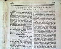
Very descriptive of St. Lucia...
Item #660235
April 01, 1782
THE LONDON MAGAZINE, England, April, 1782 Inside has over a full page article: "An Account of the Island of St. Lucia" which is very descriptive. The accompanying map called for is lacking. The other plate called for is lacking as well.
Complete in 56 pages, 5 1/4 by 8 1/4 inches, very nice condition.
Formatted very much like the Gentleman's Magazine but a much more s... See More
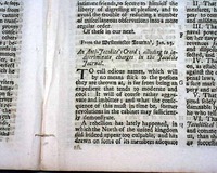
Anti-Jacobite Creed... The importance of Nova Scotia...
Item #659531
THE GENTLEMAN'S MAGAZINE, London, January, 1748 The issue begins with an: "Extract of a Letter Giving an Account of a Survey of the N. West Coast of England..." with a small print on page 2 (see). Also in this issue: "Of the Invention of Shorthand" with a full page of characters of words (see); "An Anti-Jacobite's Creed, Alluding to Indiscriminate Charges in ... See More
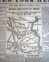
Civil War map - Corinth, Mississippi.....
Item #657802
October 06, 1862
THE NEW YORK HERALD, New York, October 6, 1862.
* Pittsburg, Tennessee
* Monterey, Tennessee
* Purdy, Tennessee
This 8 page newspaper is in nice condition (except for some margin wear) due to the use of cotton and rag paper during this very historic time in U.S. history. This issue is loaded with advertisements and Civil War reports throughout from the day it was first
... See More
This 8 page newspaper is in nice condition (except for some margin wear) due to the use of cotton and rag paper during this very historic time in U.S. history. This issue is loaded with advertisements and Civil War reports throughout from the day it was first
Map of road from London to Berwick & York... Indians visit London...
Item #657760
THE GENTLEMAN'S MAGAZINE, London, August, 1766 Articles within this issue include: "...Act for Opening & establishing certain ports in the Islands of Jamaica and Dominica for the more free importation and exportation..." "On the Doctrine of Original Sin" 'An Improvement in Common Watches" which includes a print of the gears and workings of a watch (see), and mo... See More
If you are searching for a newspaper from a specific date, please note that we have a vast selection available for purchase by using the date picker on our
gifts and birthday newspapers page.
History's Newsstand Blog
- Larger Than Life… The Death of Jessie James
- Snapshot 1903 – “Jack the Ripper” in America?
- You’ve Come A Long Way Baby. . . from the Pony Express to the internet…
- Great Story Telling is Essential to Life… Hans Christian Anderson’s Mastery of Creating the Fairytale…
Timothy Hughes Rare & Early Newspapers
P.O. Box 3636
Williamsport, PA 17701
Phone: 1-570-326-1045
Fax: 1-570-326-7606
E-mail: info@rarenewspapers.com
Hours
Monday through Friday, 7:30 - 4 (ET)
Full Contact Information
P.O. Box 3636
Williamsport, PA 17701
Phone: 1-570-326-1045
Fax: 1-570-326-7606
E-mail: info@rarenewspapers.com
Hours
Monday through Friday, 7:30 - 4 (ET)
Full Contact Information

