
Other Potential Titles... |
|
Note: In addition to what may or may not be shown below, issues may be available for this date which have yet to be listed on our website. View Potential Titles for 01/01/1500 Due to the size of our inventory, it is possible we still may have what you are looking for. Please call (570-326-1045) or send your request to info@rarenewspapers.com. |
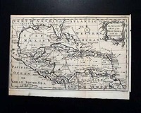
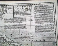
Great map of America & the West Indies...
Item #701522
THE GENTLEMAN'S MAGAZINE, London, February, 1762 * Very early Southern America map w/ West Indies
Certainly the prime feature of this early magazine is the terrific & very displayable foldout map titled: "An Accurate Map of the West Indies with the Adjacent Coast" as noted in the ornate cartouche. This map shows much of present-day Georgia & Florida to present-day... See More
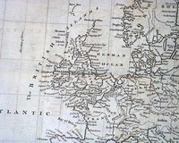
The Netherlands... with a map of Northern Europe...
Item #698019
THE GENTLEMAN'S MAGAZINE, London, June, 1744 An inside page has a report which includes: "...had a commission to be engineer with a salary of 15s a day, given him by Gen. James Oglethorpe who also conferred upon him many other favours having under pretence of sickness, left Georgia when the Spaniards came up to invade the same with a fleet and army of between 4 and 5,000 men, whi
... See More
Map of the Caribbean island of Tobago...
Item #697924
GENTLEMAN'S MAGAZINE SUPPLEMENT, London, For the Year 1778 This "Supplement" issue was published at the end of the year, and from the midst of the Revolutionary War.The best item in this issue is the very nice foldout map titled: "A Map of the Island of TOBAGO, Drawn from an Actual Survey by Thos. Bowen 1779". The map is quite detailed and measures 8 1/2 by 10 1/2 i... See More
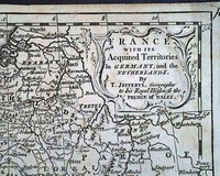
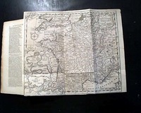
Foldout map of France... Canada content...
Item #697215
THE GENTLEMAN'S MAGAZINE, London, January, 1747
* Foldout map of France
Certainly the prime feature of this issue is the very nice foldout map titled in the cartouche: "FRANCE With Its Acquired Territories In Germany, and the Netherlands...".
This map shows considerable detail including a close-up view of the harbor & town of Toulon. The map also shows the so
... See More
* Foldout map of France
Certainly the prime feature of this issue is the very nice foldout map titled in the cartouche: "FRANCE With Its Acquired Territories In Germany, and the Netherlands...".
This map shows considerable detail including a close-up view of the harbor & town of Toulon. The map also shows the so
Oswego in the French & Indian War... Large map of Europe... Judaica item...
Item #694426
THE GENTLEMAN'S MAGAZINE, London, October, 1756 * Great & quite large map of Europe
* Oswego - French & Indian War
* Judaica - Jewish content
The prime feature would be the very nice & large foldout map titled in the cartouche: "A New & Correct CHART of EUROPE..." which shows all of Europe as well as Iceland, Russia, North Africa, a... See More
George Washington at age 22... Great map of America...
Item #694072
THE GENTLEMAN'S MAGAZINE, London, England, July, 1754
* Great American colonies mid-18th century map
* Future general & president George Washington
Inside has the continuation of an Account of the Encroachments made by the French on the British Settlements in America. In the account are the various measures taken by the British to prevent the encroachments, incl
... See More
* Great American colonies mid-18th century map
* Future general & president George Washington
Inside has the continuation of an Account of the Encroachments made by the French on the British Settlements in America. In the account are the various measures taken by the British to prevent the encroachments, incl
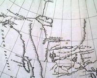
Map of Canada, Hudson Bay & other portions of North America...
Item #689565
GENTLEMAN'S MAGAZINE, London, March, 1790 * Map of Canada, Hudson Bay & other portions of North America
Certainly the prime feature of this issue is the nice, attached fold-out map: "A Map showing the communication of the Lakes and the Rivers between Lake Superior and Slave Lake in North America."
The map shows the extreme western parts of Lake Superior and "Hud... See More
Maps of Jamaica and Havana, Cuba...
Item #689163
THE GENTLEMAN'S MAGAZINE, London, April, 1762 Although typically missing from most issues, this magazine still contains the full page plate titled: "A Map Of the Island of Jamaica" which shows much detail. Accompanying this map is a nice and detailed article on Jamaica which describes it geographically, gives a bit of history on how it was settled, and some text on its economy.... See More
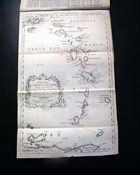
Early map of the Caribbean Islands...
Item #683352
GENTLEMAN'S MAGAZINE, London, August, 1756 The first two pages are devoted to the "Caribee Islands" [Caribbean] primarily limited to text on Barbadoes.But of greater significance is the great and desirable foldout map labeled: "A Map of the CARIBBEE ISLANDS Shewing which belong to England, France, Spain, Dutch, & Danes...". This map folds out to 8 1/2 by 13 1/2 ... See More
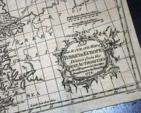
Map of the Balkan Peninsula... Turkey, Bulgaria, and more...
Item #683207
SUPPLEMENT TO THE GENTLEMAN'S MAGAZINE, London, 1770 * Map of Turkey, the Balkan Peninsula, and more.
This "Supplement" issue was produced at the end of the year. The prime content is the very nice & very detailed map, labeled in the cartouche as: "A New and Accurate Map of TURKEY IN EUROPE Drawn from the Best Authorities...1770".
This map shows the Balkan ... See More
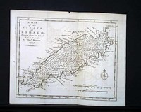
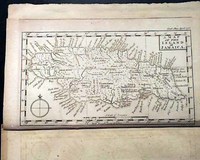
Map of the Caribbean island of Tobago...
Item #682559
GENTLEMAN'S MAGAZINE SUPPLEMENT, London, For the Year 1778 * Map of the Caribbean island of Tobago
* American Revolutionary War era
A very nice "Supplement" issue published at the end of the year, & from the Revolutionary War.
Perhaps the best item in this issue is the very nice foldout map titled: "A Map of the Island of TOBAGO, Drawn from an Actual Survey by ... See More
Terrific map of the "West Indies"... Hebrew customs discussed...
Item #682427
THE GENTLEMAN'S MAGAZINE, London, January, 1740
* Early and rare 18th century map
* West Indies & Southeast America
Certainly the prime feature of this issue is the terrific foldout map titled: "An Accurate Map of the WEST INDIES, Exhibiting not only all the Islands possessed by the English, French, Spaniards, & Dutch, but also all the Towns and Settleme
... See More
* Early and rare 18th century map
* West Indies & Southeast America
Certainly the prime feature of this issue is the terrific foldout map titled: "An Accurate Map of the WEST INDIES, Exhibiting not only all the Islands possessed by the English, French, Spaniards, & Dutch, but also all the Towns and Settleme
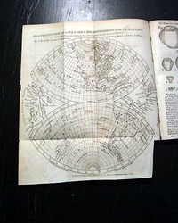
Great map showing North America... On taxing America without their consent...
Item #682287
THE GENTLEMAN'S MAGAZINE, London, April, 1776 The prime feature of this issue is the great map showing all of the western hemisphere titled: "A New Projection of the Western Hemisphere of the Earth on a Plane shewing the proportions of its several parts nearly as on a Globe, By J. Hardy, at Eton College." The map is dated at the bottom: "by F. Newbery, Ludgat
... See More
The Declaration of Independence, and more...
Item #681282
THE UNIVERSAL MAGAZINE, London, England, complete bound volume of six months for July thru December, 1776 plus the Supplement issue as well.* Original Declaration of Independence... the complete text
* As reported from Great Britain
* Entire bound volume intacted
It would be difficult to argue for a more important document in American history than the Declaration of Independence. It remai... See More
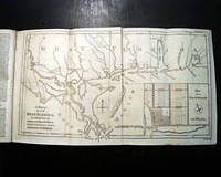
Great foldout map of "West Florida" from Pensacola to New Orleans...
Item #680579
THE GENTLEMAN'S MAGAZINE, London, England, February, 1772 * Nice map of "West Florida"
* Pensacola, Florida, to New Orleans, Louisiana
* Plate of a rare bird from the Hudson Bay
Certainly the most notable item in this issue is the very nice foldout map titled: "A Map of Part of WEST FLORIDA" from Pensacola to the Mouth of Iberville River, with a View to shew t... See More
Great map showing North America... On taxing America without their consent...
Item #677981
THE GENTLEMAN'S MAGAZINE, London, April, 1776 The prime feature of this issue is the great map showing all of the western hemisphere titled: "A New Projection of the Western Hemisphere of the Earth on a Plane shewing the proportions of its several parts nearly as on a Globe, By J. Hardy, at Eton College."
The map is dated at the bottom: "by F. Newbery, Ludg
... See More
The map is dated at the bottom: "by F. Newbery, Ludg
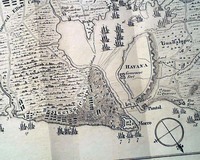
Siege of Havana, Cuba, with a foldout map...
Item #676608
GENTLEMAN'S MAGAZINE, London, October, 1762 * Siege of Havana, Cuba w/ foldout map
* British occupation - Seven Years' War
The prime content would certainly be the account of the battle of Havana, Cuba, headed: "Account of the Taking of the Havannah" which is nearly a full page account.
This is followed by the: "Articles of Capitulation agreed upon between Sir ... See More
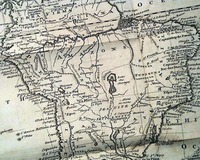
Great map of South America... Treaty of Utrecht...
Item #676521
January 01, 1749
THE GENTLEMAN'S MAGAZINE, London, January, 1749 The prime feature of this issue is the very nice & detailed foldout map of "South America" which folds out to 11 1/2 by 10 inches. A very displayable & detailed map in great condition. Among the articles within are: "Articles of the Treaty of Utrecht" between England and France, which takes over 3 p
... See More
Lengthy Judaica item, plus the founding of Georgia...
Item #676454
THE GENTLEMAN'S MAGAZINE, London, February, 1731 There are several notable articles in this issue, including over a full page on: "...an Historical and Law-Treatise Against Jews and Judaism, published some years since."Another significant item is one of the earliest reports to be had on what would be the creation of the Georgia colony, headed: "A true Account of a new Co... See More

Oswego during the French & Indian War, with maps...
Item #670988
THE GENTLEMAN'S MAGAZINE, London, February, 1757
* Forts Oswego and Ontario
* French and Indian war with map
Among the inside pages is a quite lengthy & detailed article titled: "An Historical Account of American Affairs during the Two last years, with a particular journal of the Siege & Surrender of Oswego" with this text taking over six pages (see photo
... See More
* Forts Oswego and Ontario
* French and Indian war with map
Among the inside pages is a quite lengthy & detailed article titled: "An Historical Account of American Affairs during the Two last years, with a particular journal of the Siege & Surrender of Oswego" with this text taking over six pages (see photo
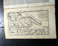
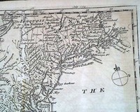
Creating the Mason-Dixon Line: map of America...
Item #666701
THE GENTLEMAN'S MAGAZINE, London, December, 1769* Early America map
* Pennsylvania and Maryland
* Mason and Dixon Line creation
Certainly the prime feature of this issue is the nice full page map of the Chesapeake region showing parts of Virginia, Maryland, Pennsylvania, New Jersey, and all of Delaware.
The inset in the lower right corner reads: "A Map of that Part of America wh... See More
Map of France... Cape Breton & Louisbourgh in Canada...
Item #640453
THE GENTLEMAN'S MAGAZINE, London, January, 1747
* Foldout map of France
Certainly the prime feature of this issue is the very nice foldout map titled in the cartouche: "FRANCE With Its Acquired Territories In Germany, and the Netherlands..." (see). This map shows considerable detail including a close-up view of the harbor & town of Toulon. The map also shows th
... See More
* Foldout map of France
Certainly the prime feature of this issue is the very nice foldout map titled in the cartouche: "FRANCE With Its Acquired Territories In Germany, and the Netherlands..." (see). This map shows considerable detail including a close-up view of the harbor & town of Toulon. The map also shows th
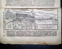
Death of Jonathan Swift... Early printing of "God Save the King"... Battle charts...
Item #639043
THE GENTLEMAN'S MAGAZINE, London, October, 1745 A highlight of this issue is the interesting and unusual full page engraving of: "A Plan of the City of Edinburgh" which has much detail, showing the castle as well, and includes a rather large key to various locations as well (see). Further on is a very detailed article: "Description of the City of Edinburgh".
Anot
... See More
Anot
Edison's phonograph... Oil regions of Pennsylvania... Morgan Silver Dollar...
Item #174230
March 30, 1878
HARPER'S WEEKLY, New York, March 30, 1878 The full front page is a Thomas Nast political cartoon: "Fulfill Your Promises" and a fullpg. inside has another Nast political cartoon: "Our Uncle's 'Honor' Touched" showing Uncle Sam.
The great doublepage centerfold: 'The Oil Regions of Pennsylvania' shows 11 scenes and is very displayable. The feature s... See More
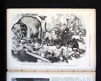
Thomas Nast's first Republican elephant print... Homer print...
Item #173876
November 07, 1874
HARPER'S WEEKLY, New York, Nov. 7, 1874 The full front page is a Thomas Nast political cartoon: "A Tammany Rat", but certainly the most significant print in this issue is another full page Thomas Nast political cartoon titled: 'The 3rd term Panic' which shows the Republican elephant for the first time. Thomas Nast was the creator of both the Republican elephant and the ... See More
If you are searching for a newspaper from a specific date, please note that we have a vast selection available for purchase by using the date picker on our
gifts and birthday newspapers page.
History's Newsstand Blog
- Snapshot 1903 – “Jack the Ripper” in America?
- You’ve Come A Long Way Baby. . . from the Pony Express to the internet…
- Great Story Telling is Essential to Life… Hans Christian Anderson’s Mastery of Creating the Fairytale…
- “Collecting Newspapers – The Basics” (Part V) – Reprints…
Timothy Hughes Rare & Early Newspapers
P.O. Box 3636
Williamsport, PA 17701
Phone: 1-570-326-1045
Fax: 1-570-326-7606
E-mail: info@rarenewspapers.com
Hours
Monday through Friday, 7:30 - 4 (ET)
Full Contact Information
P.O. Box 3636
Williamsport, PA 17701
Phone: 1-570-326-1045
Fax: 1-570-326-7606
E-mail: info@rarenewspapers.com
Hours
Monday through Friday, 7:30 - 4 (ET)
Full Contact Information

